News from the South - Alabama News Feed
Tracking the Tropics: Helene likely forms in the Gulf this week and becomes a hurricane, and Alab…
SUMMARY: A significant weather event is unfolding as a cold front moves southward, with tropical thunderstorms developing in the Caribbean. The National Hurricane Center predicts an 80% chance of this activity becoming a tropical cyclone, likely named Helene, which could become a tropical storm by Tuesday and a hurricane by Wednesday. The forecast suggests a path towards Panama City or further east. Central Alabama can expect temperatures around 90°F, with isolated showers in the next few days. A cold front is projected to bring heavier storms and gusty winds by Thursday, potentially impacting high school football events, with rain totals of 1-4 inches expected.

Tracking the Tropics: Helene likely forms in the Gulf this week and becomes a hurricane, and Alabama’s weather forecast includes some impacts
Subscribe to WVTM on YouTube now for more: https://bit.ly/2jvAaUD
Get more Birmingham news: http://www.wvtm13.com
Like us: https://www.facebook.com/WVTM13/
Follow us: https://twitter.com/WVTM13
Instagram: https://www.instagram.com/wvtm13/


News from the South - Alabama News Feed
Alabama immigration enforcement bill gets approval from 2nd House committee
by Ralph Chapoco, Alabama Reflector
April 3, 2025
An Alabama House committee Wednesday approved an immigration bill that had already received another committee’s approval earlier in the session.
The House Judiciary Committee approved HB 7, sponsored by Rep. Ernie Yarbrough, R-Trinity, which would give local law enforcement the authority to enforce the country’s immigration laws.
“There are no new laws added,” Yarbrough said to committee members during the meeting. “It simply allows that partnership to take place just to address safety in our communities.”
GET THE MORNING HEADLINES.
Judiciary approved the bill about six weeks after the House Public Safety and Homeland Security did so in February. It is unusual for a bill to go through two committees before going to the floor of the House for a vote. The last major legislation to get routed through two House committees was the bill legalizing medical cannabis in Alabama in 2021.
The current bill, largely unchanged from last year, allows local law enforcement, such as sheriff’s offices and police departments, to enter into agreements with federal agencies to arrest and detain people who are not legally authorized to reside in the country.
Once in custody, deputies and police officers must then attempt to determine a person’s immigration status and get the help of an interpreter to determine someone’s nationality.
If a person cannot provide documentation proving they are eligible to live in the country, local law enforcement may then reach out to a Law Enforcement Support Center (LESC) to get information about a person’s immigration status.
The bill states that people cannot be detained solely because of their immigration status unless authorized by Immigration and Customs Enforcement, and that sheriffs’ deputies and police departments will verify that a person has an arrest warrant within 24 hours of the person getting detained.
Law enforcement must also obtain documents to verify a person’s immigration status, bet that a passport or a permanent resident card.
House Judiciary Committee members approved an amendment making a few of the requirements optional. A previous version required the Alabama Attorney General’s Office to publicly name any agency failing to comply with provisions in the legislation and notify the governor’s office.
The updated language gives the AG’s Office an option to inform the Governor’s Office.
Another amendment also allows, but doesn’t require, local law enforcement to report the total number of people arrested and the number of foreign nationals they take into custody as well as the inquiries they make to the LESC.
Immigration advocates who spoke at a public hearing on the legislation in March said the legislation is creating fear among immigrant communities. That, they said, would lead to mistrust toward law enforcement and increased school truancy for children of immigrants who are afraid to attend school for fear of their parents being deported.
Democrats on the House Judiciary Committee criticized the legislation.
“What country do we border in Alabama?” asked Rep. Penni McClammy, D-Montgomery during the committee meeting Wednesday.
Yarbrough said that every state is connected, and that people travel.
“Each state doesn’t have a physical wall, so people travel from state to state,” Yarbrough said.
YOU MAKE OUR WORK POSSIBLE.
Alabama Reflector is part of States Newsroom, a nonprofit news network supported by grants and a coalition of donors as a 501c(3) public charity. Alabama Reflector maintains editorial independence. Contact Editor Brian Lyman for questions: info@alabamareflector.com.
The post Alabama immigration enforcement bill gets approval from 2nd House committee appeared first on alabamareflector.com
News from the South - Alabama News Feed
New Tariffs Could Raise Car Prices | April 2, 2025 | News 19 at 10 p.m.
SUMMARY: A 25% tariff on foreign cars and auto parts is set to take effect at midnight, potentially raising prices for consumers. While current inventory and cars already at U.S. ports will remain at existing prices, future pricing remains uncertain. Dealerships in North Alabama say it’s too early to know the full impact, but warn that repair costs may also rise due to higher parts prices. Some manufacturers may absorb part of the tariff, while others could pass the full cost to buyers—raising a $30,000 car to nearly $40,000. Dealerships report a recent surge in buyers trying to purchase before prices rise.

A 25% tariff on any foreign cars or auto parts will go into effect in a couple of hours.
News 19 is North Alabama’s News Leader! We are the CBS affiliate in North Alabama and the Tennessee Valley since November 28, 1963.
https://whnt.com/
https://www.facebook.com/whntnews19
https://www.instagram.com/whntnews19/
https://twitter.com/whnt
News from the South - Alabama News Feed
Weather Fun 1on1: Brylee explains why thunderstorms occur more often in the summer than in the wi…
SUMMARY: Meteorologist Brylee Brown explains why thunderstorms are more common in summer than winter in her “Weather Fun 1-on-1” segment. Joined by Aidan, they conduct an experiment using two bowls of air at different temperatures. The warm air inflates a balloon, demonstrating that warm air is less dense and rises, while cold air causes the balloon to deflate. This principle helps explain why summer afternoons often bring air mass thunderstorms, as humid, warm air is abundant. In winter, less warm air means these storms are rare. For more weather science resources, viewers can scan a QR code or visit the website.

Weather Fun 1on1: Brylee explains why thunderstorms occur more often in the summer than in the winter
Subscribe to WVTM on YouTube now for more: https://bit.ly/2jvAaUD
Get more Birmingham news: http://www.wvtm13.com
Like us: https://www.facebook.com/WVTM13/
Follow us: https://twitter.com/WVTM13
Instagram: https://www.instagram.com/wvtm13/

Boeing announces support of Delta State’s commercial aviation program
Gov. Tate Reeves working on plan to call special session after budget collapse

Tennessee Senate passes bill limiting legal liability of pesticide makers | Tennessee

Helene: Death toll 107 in North Carolina, 236 in seven states | North Carolina

Senate Republicans to vote on budget plan permanently extending Trump tax cuts | National

Early voting proposal killed on last day of Mississippi legislative session

K-12 schools must sign certification against DEI to receive federal money, administration says

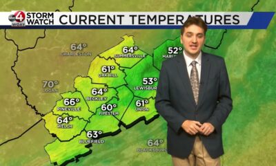
Braden's April 3 Forecast: Severe Weather Early

East Union girls powerlifting continues streak of dominance

University of Houston Cougars greeted in San Antonio ahead of Final Four

Pharmacy benefit manager reform likely dead

University of Alabama student detained by ICE moved to Louisiana

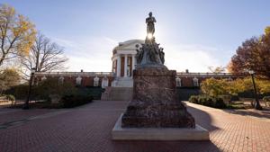
Youngkin removes Ellis, appoints Cuccinelli to UVa board | Virginia

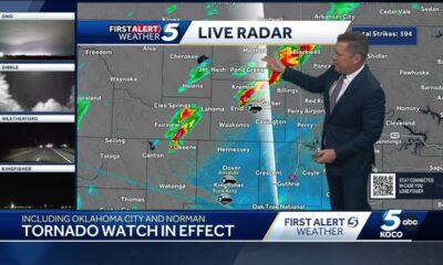
Tornado watch, severe thunderstorm warnings issued for Oklahoma

Georgia road project forcing homeowners out | FOX 5 News

Hometown Hero | Restaurant owner serves up hope

Budget cuts: Senior Citizens Inc. and other non-profits worry for the future

Tornado practically rips Bullitt County barn in half with man, several animals inside

Strangers find lost family heirloom at Cocoa Beach

Chesterfield man accused of killing father
Braden's April 3 Forecast: Severe Weather Early
East Union girls powerlifting continues streak of dominance
University of Houston Cougars greeted in San Antonio ahead of Final Four

Colorado State University researchers predict above-average 2025 Atlantic hurricane season

Former Republican congressman warns Trump’s tariffs could bring ‘severe consequences’

Waking Up with Wesley: Another breezy day ahead, cooldown coming (4/3/25)

4/2 -Sam Parker’s “Wow It’s Windy” Wednesday Night Forecast

National Burrito Day with Roberts Place Cafe

Ready for spring cleaning? Here are some tips to clean up your gardens

Reproductive Justice Fund up for another San Antonio City Council vote Thursday
-

 Mississippi Today2 days ago
Pharmacy benefit manager reform likely dead
-
 News from the South - Alabama News Feed6 days ago
University of Alabama student detained by ICE moved to Louisiana
-
 News from the South - Virginia News Feed6 days ago
Youngkin removes Ellis, appoints Cuccinelli to UVa board | Virginia
-
News from the South - Oklahoma News Feed5 days ago
Tornado watch, severe thunderstorm warnings issued for Oklahoma
-
News from the South - Georgia News Feed5 days ago
Georgia road project forcing homeowners out | FOX 5 News
-
News from the South - West Virginia News Feed6 days ago
Hometown Hero | Restaurant owner serves up hope
-
News from the South - Georgia News Feed6 days ago
Budget cuts: Senior Citizens Inc. and other non-profits worry for the future
-
News from the South - Kentucky News Feed3 days ago
Tornado practically rips Bullitt County barn in half with man, several animals inside