News from the South - Louisiana News Feed
Tracking possible development in the tropics and a long stretch of dangerous heat
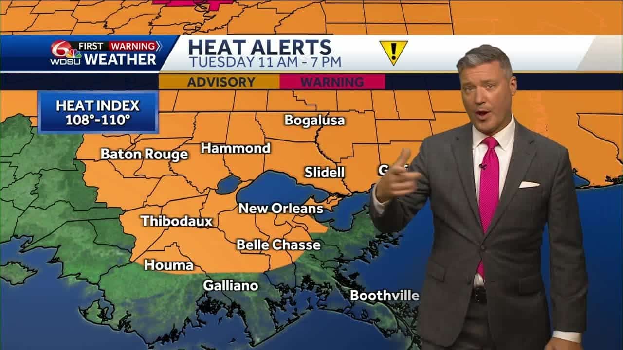
SUMMARY: Today is an impact day due to extreme heat, with temperatures feeling like 110°F in some areas. A heat advisory is in effect as highs reach the 90s. The weather report includes monitoring potential storms in the tropics, currently weak but may develop as it encounters warm waters and higher humidity. There’s a 50% chance of development impacting areas like Puerto Rico and the Dominican Republic, though current forecasts suggest it will stay away from the U.S. Isolated showers are expected, with real-time conditions projecting continued heat into the upcoming week, possibly alleviated by scattered storms later.

Meteorologist Devon Lucie first takes us to the Atlantic showing us where a very weak system is expected to interact with a tropical wave and could become a tropical system by the weekend and lets us know what impact it could have for us, then comes back home to talk about the heat and expected upcoming Heat Advisories that will warrant WDSU First Warning Weather Impact Days, he’ll let you know how hot we’ll get, how hot we’ll feel, and how long this heat wave will last.
Subscribe to WDSU on YouTube now for more: http://bit.ly/1n00vnY
Get more New Orleans news: http://www.wdsu.com
Like us: http://www.facebook.com/wdsutv
Follow us: http://twitter.com/wdsu
Instagram: https://www.instagram.com/wdsu6/


News from the South - Louisiana News Feed
Louisiana leaders offer condolences in remembrance of Pope Francis

SUMMARY: Louisiana officials, including Archbishop Gregory Aymond and Governor Jeff Landry, have expressed condolences following the death of Pope Francis, who served as the 266th Pope of the Catholic Church for 12 years. Pope Francis passed away shortly after delivering his final Easter Mass on April 20. Leaders highlighted his compassion, humility, and dedication to the marginalized. Congressman Troy Carter praised the Pope’s unwavering moral clarity, while Senator Bill Cassidy noted his focus on mercy. Local representatives shared personal memories, acknowledging the profound impact Pope Francis had on global communities and his leadership in promoting justice, mercy, and peace.
The post Louisiana leaders offer condolences in remembrance of Pope Francis appeared first on wgno.com
News from the South - Louisiana News Feed
KSAT's RJ Marquez breaks down life of Pope Francis after his passing

SUMMARY: Pope Francis, the first Latin American pontiff, passed away at 88, marking the end of a transformative papacy that began in 2013. Known for his humility and dedication to the poor, he engaged with global issues like capitalism and climate change, which alienated some conservatives. He had recently faced health challenges, including chronic lung disease and double pneumonia. His approachable style included riding in an open-air car and washing prisoners’ feet. He advocated for tolerance within the Church, notably addressing LGBTQ+ issues and emphasizing zero tolerance for child sex abuse. His legacy will continue to impact the Catholic Church and the world.

Church bells tolled in mourning. Well-wishers flocked into pews. Tributes to Pope Francis poured in from around the world on Monday after the Vatican announced the pontiff’s death at age 88.
News from the South - Louisiana News Feed
Judge to weigh Louisiana AG’s challenge to New Orleans jail’s ‘sanctuary’ policy

by Bobbi-Jean Misick, Verite, Louisiana Illuminator
April 20, 2025
NEW ORLEANS – Louisiana Attorney General Liz Murrill is pushing forward with her efforts to force Orleans Parish Sheriff Susan Hutson to drop a longtime policy that generally prohibits deputies from directly engaging in federal immigration enforcement within the city’s jail.
In legal filings, Murrill claims the policy — which the state characterizes as a so-called “sanctuary city” policy — is in direct conflict with a newly passed state law that requires state and local law enforcement agencies to cooperate with federal immigration agencies.
“The consent decree now sits fundamentally at odds with state law as applicable to immigration detainers,” Murrill said in court documents filed Friday (April 11).
A federal court will now determine whether to allow the state of Louisiana to join a 2011 federal suit that resulted in the policy and whether to throw out the policy altogether. A hearing has been set for April 30.
GET THE MORNING HEADLINES.
The state’s campaign against “sanctuary” policies comes as President Donald Trump is pushing local law enforcement agencies to join the federal government in his promised immigration crackdown. Since his inauguration, Trump has ordered the U.S. Department of Homeland Security to push for more partnerships between local law enforcement units and federal immigration agencies. A few have already signed up. Louisiana Gov. Jeff Landry, a longtime immigration hardliner and Trump ally, has worked with Republican lawmakers in the state to enact laws that encourage those collaborations.
As attorney general, Landry criticized a policy adopted by the New Orleans Police Department, under a long-running federal consent decree that blocks officers from enforcing immigration laws.
Neither Murrill’s office nor representatives for U.S. Immigration and Customs Enforcement responded to requests for comment.
In court filings, Murrill said Hutson “does not oppose the [state’s] intervention” in the case.” But a spokesperson for Hutson said that’s not exactly true.
“It’s more accurate that we take no position regarding the state intervention,” a Sheriff’s Office spokesperson said in an emailed statement on Wednesday.
While she has not taken a position for or against increased collaboration with ICE, in an interview with Fox 8 in December, Hutson noted that the jail’s resources were far too stretched to take on immigration enforcement.
“I’m a lawyer. I believe in following the law and court orders and we do that and so that’s what we’re gonna do, continue to follow the law, but I cannot do ICE’s work,” she said. “It’s too big of a load.”
Potential conflict
The sheriff’s policy stems from a 2013 federal court settlement in a civil rights case involving two New Orleans construction workers picked up on minor charges in 2009 and 2010.
Mario Cacho and Antonio Ocampo sued after they were allegedly illegally held in the city’s jail past the completion of their sentences. The two were held at the request of U.S. Immigration and Customs Enforcement. The agency issues such “detainer” requests to local law enforcement agencies, asking them to hold onto arrestees who are suspected of immigration violations.
Local agencies are only supposed to honor the hold requests for 48 hours, after which they should let detainees free. But in 2009 and 2010, then-Sheriff Marlin Gusman detained Cacho and Ocampo for months, according to legal filings in their case against the office.
Ocampo and Cacho settled the case with the Sheriff’s Office in 2013, and Gusman agreed to adopt a new policy on immigration investigations. The resulting policy blocks the agency from investigating immigration violations and from detaining immigrants for ICE without a court order, except in certain cases where they are facing charges for a small number of serious violent crimes.
Attorneys for Cacho and Ocampo declined to speak with Verite News on the record. However, filings they submitted to the court last week opposing the state’s intervention in the case argue that Murrill has “blatantly misrepresented the OPSO policy” by falsely claiming it forces the Sheriff’s Office to disregard all ICE detainers.
The sheriff’s office, like the NOPD, has been under a sweeping federal consent decree for more than a decade. But unlike the NOPD, the jail’s consent decree does not demand that deputies stay away from federal immigration enforcement, only that it release anyone subject to an immigration hold after two days. The Justice Department’s Civil Rights Division, which is a party to both consent decrees, has not entered any filings since Murrill moved to bring the state into the Cacho and Ocampo case.
The Department of Justice did not respond to a request for comment.
The OPSO policy remained in place for more than a decade without any controversy until last spring, when the Louisiana Legislature passed a bill — Act 314 — that blocks so-called “sanctuary” policies prohibiting state and local law enforcement officers from cooperating with federal immigration agencies like ICE.
A sheriff’s office spokesperson spokesperson said the agency’s policy on ICE detainers is “governed” by the consent judgement in the case. She declined to comment further, as the state is currently challenging the policy, but affirmed that OPSO is “in full compliance with all applicable state laws and valid court orders related to ICE detainers.”
YOU MAKE OUR WORK POSSIBLE.
This article first appeared on Verite News New Orleans and is republished here under a Creative Commons Attribution-NoDerivatives 4.0 International License. PARSELY = { autotrack: false, onload: function() { PARSELY.beacon.trackPageView({ url: “https://veritenews.org/2025/04/16/judge-to-weigh-new-orleans-jail-sanctuary-murrill/”, urlref: window.location.href }); } }
Louisiana Illuminator is part of States Newsroom, a nonprofit news network supported by grants and a coalition of donors as a 501c(3) public charity. Louisiana Illuminator maintains editorial independence. Contact Editor Greg LaRose for questions: info@lailluminator.com.

Election Day is almost here. What to know before voting in Mississippi’s municipal primary runoffs

Eight-grade boy stabbed by fellow classmate at Memphis school, family says

Pope Francis, first Latin American pontiff who ministered with a charming, humble style, dies at 88

WTOK Weather – Zack Rogers 4/19/25

Louisiana leaders offer condolences in remembrance of Pope Francis

Meteorologist Chita Craft is tracking a Severe Thunderstorm Warning that's in effect now

GMSA+ : Apr 21, 2025

How is the next pope selected?

Cannabis Festival brings education on marijuana health benefits

KSAT's RJ Marquez breaks down life of Pope Francis after his passing

Foley man wins Race to the Finish as Kyle Larson gets first win of 2025 Xfinity Series at Bristol

Federal appeals court upholds ruling against Alabama panhandling laws

Drivers brace for upcoming I-70 construction, slowdowns

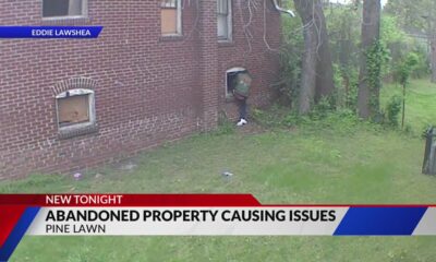
Abandoned property causing issues in Pine Lawn, neighbor demands action

See how much your Mississippi school district stands to lose in Trump’s federal funding freeze

FDA warns about fake Ozempic, how to spot it

Lieutenant governor race heats up with early fundraising surge | Virginia

Heart disease survivor spends 15th birthday raising money for American Heart Association

Tax rebate coming soon to some Georgians | Georgia

Thursday April 17, 2025 TIMELINE: Severe storms Friday
Eight-grade boy stabbed by fellow classmate at Memphis school, family says
Pope Francis, first Latin American pontiff who ministered with a charming, humble style, dies at 88
WTOK Weather – Zack Rogers 4/19/25
Meteorologist Chita Craft is tracking a Severe Thunderstorm Warning that's in effect now
GMSA+ : Apr 21, 2025
Cannabis Festival brings education on marijuana health benefits
KSAT's RJ Marquez breaks down life of Pope Francis after his passing

University of Missouri unveils billion-dollar reactor project

South Florida 11 p.m. Weather Forecast 4/20/2025

Car lovers, families gather for Midwest Easter Car & Bike Show
-

 News from the South - Alabama News Feed7 days ago
Foley man wins Race to the Finish as Kyle Larson gets first win of 2025 Xfinity Series at Bristol
-
 News from the South - Alabama News Feed7 days ago
Federal appeals court upholds ruling against Alabama panhandling laws
-
News from the South - Missouri News Feed4 days ago
Drivers brace for upcoming I-70 construction, slowdowns
-
Mississippi Today4 days ago
See how much your Mississippi school district stands to lose in Trump’s federal funding freeze
-
News from the South - North Carolina News Feed6 days ago
FDA warns about fake Ozempic, how to spot it
-
 News from the South - Virginia News Feed5 days ago
Lieutenant governor race heats up with early fundraising surge | Virginia
-
News from the South - Missouri News Feed6 days ago
Abandoned property causing issues in Pine Lawn, neighbor demands action
-
News from the South - West Virginia News Feed7 days ago
Heart disease survivor spends 15th birthday raising money for American Heart Association