Local News Video
Meteorologist Trey Tonnessen: “Surface Analysis” 6PM Forecast

SUMMARY: The Weather Authority predicts a cool night and relatively warmer temperatures compared to the previous night. Christmas decorations are in place, but rainfall is expected tomorrow. The current temperatures are in the upper 40s and lower 50s, with winds coming from the south-southeast. The Gulf Coast is experiencing similar temperatures as Florida, while Texas is in the 60s. A warm front is moving in, bringing the potential for thunderstorms. The surface analysis shows high pressure moving east and clouds drifting in from the west. There is a possibility of strong storms developing by Thursday and Friday. Rain chances are indicated on the 7-day forecast.

Wednesday November 29th, 2023: here is a lot of uncertainty and right
now the best forecast shot is storms will begin to roll into
northwestern portions of the CWA around 06z Fri and work east given
the mid lvl pattern there is a high chance that the storms take on a
WSW to ENE orientation during the early morning hours a few strong
possibly severe storms can not be ruled out initially maybe between
5/6z till 8/9z but after that there appears to be a much better
chance of a heavy rain setup developing. All of the dynamics will
quickly pull away to the NE or even NNE Thursday night and this is
very common with convection waning (at least the risk for
strong/severe). This also will lead to the sfc low pulling away well
north of the area quickly and with no forcing or strong cold air
mass behind it the line will slow down considerably and that is when
the convection would take on that orientation and we could see a
line of training storms. Abundant moisture will be in place and very
strong LL convergence initially should lead to favorable
thunderstorms development and even help to possiblity of
strong/severe storms with very strong shear in place but quickly the
core of the LL jet will lift north with the dynamics and the
potentency of storms should begin to wane.
Local News Video
Expert Talk – Senior Medicare Patrol (Telehealth Fraud)

SUMMARY: In this episode of WXXV’s Expert Talk, host Michelle Eubank welcomes Danielle Gillery from Senior Medicare Patrol to discuss telehealth, which gained prominence during the COVID pandemic. Telehealth allows patients to consult with doctors via video calls rather than in person. However, telehealth fraud occurs when individuals are billed for services from providers they’ve never interacted with, such as cases where nurses, rather than doctors, diagnose readings. Gillery advises viewers who suspect fraud to contact Medicare or the Senior Medicare Patrol for assistance. The organization provides resources to help resolve billing issues and combat scams.

Local News Video
Dream Home Giveaway supports St. Jude families

SUMMARY: The St. Jude Dream Home Giveaway supports families like Charlie’s, who benefited from the hospital’s free treatment for bone cancer. In 2020, after Charlie injured his shoulder, a specialist at St. Jude diagnosed him with Ewing sarcoma, leading to 14 rounds of chemotherapy and a limb-sparing surgery. The treatment, costing $2 million, was entirely free for the family, including housing, gas, and food. Now 15, Charlie helps raise millions for St. Jude and continues regular check-ups. The Dream Home Giveaway not only offers a chance to win a house but also supports the life-saving work at St. Jude.

Tickets for the home in Gulfport are $100, and proceeds benefit the St. Jude’s Children Hospital.
For more Local News from WLOX: https://www.wlox.com/
For more YouTube Content: https://www.youtube.com/channel/UCQZgBHlQMqHUV_hf4_9jLLQ
Local News Video
14-year-old receives encouraging words from Morgan Freeman ahead of Ground Zero performance

SUMMARY: Fourteen-year-old John Clayton White is set to perform at Ground Zero in Biloxi, drawing praise for his prodigious blues talent. Morgan Freeman, a co-owner of the venue with a distinguished career, shared his excitement during an interview. He emphasized the importance of nurturing young talent while recognizing the historical significance of blues music, which originated in Mississippi. Freeman expressed hope that the support from audiences would encourage Clayton to excel in his craft. The event promises a blend of rich musical heritage and emerging talent, aiming to provide a memorable entertainment experience. The show begins at 7 p.m. at Ground Zero.

14-year-old John Clayton White will take the stage at Ground Zero in Biloxi on Friday.
For more Local News from WLOX: https://www.wlox.com/
For more YouTube Content: https://www.youtube.com/channel/UCQZgBHlQMqHUV_hf4_9jLLQ
-

 News from the South - Alabama News Feed6 days ago
Foley man wins Race to the Finish as Kyle Larson gets first win of 2025 Xfinity Series at Bristol
-

 News from the South - Alabama News Feed6 days ago
Federal appeals court upholds ruling against Alabama panhandling laws
-

 News from the South - North Carolina News Feed5 days ago
FDA warns about fake Ozempic, how to spot it
-

 News from the South - Virginia News Feed4 days ago
Lieutenant governor race heats up with early fundraising surge | Virginia
-

 News from the South - Arkansas News Feed6 days ago
Two dead, 9 injured after shooting at Conway park | What we know
-

 News from the South - Missouri News Feed5 days ago
Abandoned property causing issues in Pine Lawn, neighbor demands action
-

 News from the South - Oklahoma News Feed3 days ago
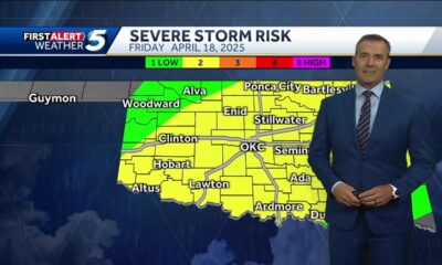
Thursday April 17, 2025 TIMELINE: Severe storms Friday
-

 News from the South - Missouri News Feed3 days ago
Drivers brace for upcoming I-70 construction, slowdowns


