News from the South - Louisiana News Feed
Louisiana faces rising long-term pension liability burden | Louisiana
SUMMARY: In fiscal 2023, Louisiana’s long-term liabilities rose to $17.2 billion, equal to 6.4% of personal income, indicating a growing financial burden on residents. Adjusted net pension liabilities increased to $9.4 billion or 3.5% of personal income, while direct state debt slightly decreased to $7.8 billion (2.9% of personal income). The state’s pension systems faced challenges due to weaker asset values and declining funding ratios. Legal barriers complicate the management of pension obligations, and despite the rise in liabilities, Louisiana maintains a stable direct debt profile. The AA- issuer default rating reflects its ability to handle fiscal pressures, albeit with ongoing pension challenges.
The post Louisiana faces rising long-term pension liability burden | Louisiana appeared first on www.thecentersquare.com


News from the South - Louisiana News Feed
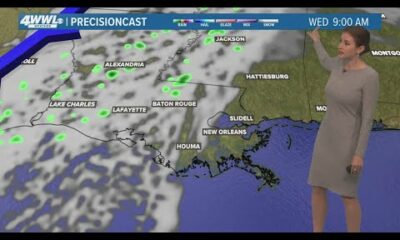
New Orleans Weather: Warming up through Wednesday with a few showers
SUMMARY: New Orleans weather is warming up through Wednesday, with temperatures rising from the 60s to around 80°F by then. Currently, it’s sunny with a refreshing north wind, perfect for outdoor activities like the Downtown Irish Club parade. Tonight’s temperatures will dip to the 50s on the Southshore and middle 40s Northshore. A few showers may occur Wednesday, but most of the rain is expected Sunday night into Monday, possibly bringing up to an inch of rain. Overall, the 7-day forecast looks pleasant with highs in the upper 60s to 70s and no major storms predicted for the weekend.

Meteorologist Alexandra Cranford shows pleasant weather ahead for much of the week. Forecast from Monday, March 17, 2025 at noon
News from the South - Louisiana News Feed
Area of low-pressure in the tropics is unlikely to develop
SUMMARY: A low-pressure system in the subtropical central Atlantic is unlikely to develop, with only a 10% chance over the next week due to unfavorable conditions. In Southeast Louisiana, a high-pressure system is bringing dry air and mild temperatures, around 65°F. The forecast for today includes sunny skies and temperatures reaching the lower 70s. Tonight, lows will drop into the 40s and 50s. The rest of the week will see temperatures warm into the mid to upper 70s, with a cold front expected Thursday. Expect a mix of clouds and sunshine, with a slight chance of showers on Wednesday.

There is a non-tropical area of low pressure located about 700 miles northeast of the northern Leeward Islands, according to the …
SUMMARY: On Monday, March 17th, temperatures start cold in the lower 40s, dropping to the upper 30s in some areas. However, bright sunny conditions will lead to a warm-up into the mid-70s by afternoon. Calm winds will shift as high pressure moves southeast, increasing to 5-10 mph later today and 15-20 mph by Tuesday. Expect milder evening lows around 50°F. Cloud cover and possible light showers may develop by Wednesday with a frontal boundary approaching. Temperatures will drop to the 60s later in the week but rebound to near 80°F by next weekend. Enjoy today’s pleasant weather!

High pressure has settled in helping to keep conditions clear and pleasant to kick off this Monday. An upper level low will track across Kansas helping to build a pressure gradient between the high pressure near the gulf coast. This will help to increase winds through tomorrow becoming breezy. A frontal system will arrive on Wednesday sparking up some clouds and a few patchy showers. A t-storm will be possible as well. Then we cool down late week to the lower 60’s for highs with mostly clear conditions. Our next best chance of rain and thunderstorms will come late weekend next Sunday with warming temperatures near lower 80’s.

Grace residents cleaning up after storms

‘It’s almost enough to make you cry': Crabapple Fire victims share stories, support from neighbors

Crabapple Wildfire: Fire in Gillespie County now over halfway contained | FOX 7 Austin

Houston-area midwife arrested for allegedly providing illegal abortions

Celebrating National Athletic Training Month

Hanceville Mayor Issues Statement on Disbanding of PD | March 17, 2025 | News 19 at 4 p.m.

NWS confirms tornadoes with EF-0 to EF-3 strength as teams survey damage paths

Woman shares story after grandpa struck by stray bullet in Florida City

Red Cross aids Mississippi families after tornado outbreak

From 4-leaf clovers to some unexpected history, all you need to know about St. Patrick’s Day

Long Story Short: Bill to Boost Rural Mental Health and Diversion Programs Advances

Blood stain leads to 2 arrests in 1997 Oklahoma cold case

Cannabis cultivator celebrates Alabama licensing ruling

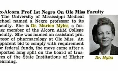
On this day in 1965

Lost in the Fire: The flames took her brother and left her homeless

Louisiana spent $2.4B to improve Medicaid. A lot of the money went to administrative functions.

Oak Ridge searching for lifeguards while preparing to open pools for the summer

Community seeks answers after break-in at high school fieldhouse

Housing First homeless outreach in-person in Mobile, Baldwin

5 On Your Side: What do egg labels really mean?
Grace residents cleaning up after storms
‘It’s almost enough to make you cry': Crabapple Fire victims share stories, support from neighbors
Crabapple Wildfire: Fire in Gillespie County now over halfway contained | FOX 7 Austin
Hanceville Mayor Issues Statement on Disbanding of PD | March 17, 2025 | News 19 at 4 p.m.
NWS confirms tornadoes with EF-0 to EF-3 strength as teams survey damage paths
Woman shares story after grandpa struck by stray bullet in Florida City
Red Cross aids Mississippi families after tornado outbreak

New Orleans Weather: Warming up through Wednesday with a few showers

Area of low-pressure in the tropics is unlikely to develop

Bluegrass Community & Technical College
-

 News from the South - Oklahoma News Feed6 days ago
Long Story Short: Bill to Boost Rural Mental Health and Diversion Programs Advances
-
News from the South - Oklahoma News Feed6 days ago
Blood stain leads to 2 arrests in 1997 Oklahoma cold case
-
News from the South - Alabama News Feed6 days ago
Cannabis cultivator celebrates Alabama licensing ruling
-
Mississippi Today4 days ago
On this day in 1965
-
News from the South - South Carolina News Feed3 days ago
Lost in the Fire: The flames took her brother and left her homeless
-
News from the South - Louisiana News Feed6 days ago
Louisiana spent $2.4B to improve Medicaid. A lot of the money went to administrative functions.
-
News from the South - Tennessee News Feed6 days ago
Oak Ridge searching for lifeguards while preparing to open pools for the summer
-
News from the South - West Virginia News Feed5 days ago
Community seeks answers after break-in at high school fieldhouse