News from the South - Alabama News Feed
Helene is now a Hurricane
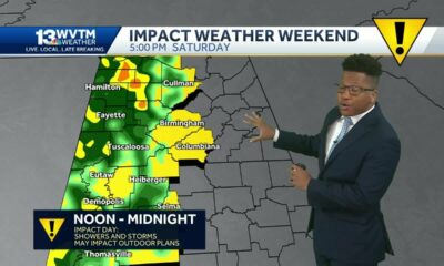
SUMMARY: Hurricane Helen is currently strengthening as it approaches the Gulf of Mexico, with maximum winds of 80 mph. The storm is moving north-northwest at 10 mph and is expected to reach category 2 status soon, potentially becoming a category 3 hurricane by tomorrow morning. It’s forecasted to make landfall near Appalachicola around 7 PM tomorrow, weakening quickly afterward. While the Gulf Coast will experience breezy conditions and a tropical storm warning in waterways, significant storm surge impacts will be focused on the eastern side of the storm. Rain chances and rough surf may affect Northwest Florida, so residents should stay informed on the latest developments.

HURRICANE HELENE is now a hurricane and will continue to strengthen as it enters the Gulf. The system continues to become more organized and is set for a period of possible rapid intensification. The storm is expected to become major hurricane by Thursday morning.
Right now, NHC has Helene picking up speed as it gets picked up by and upper-level trough. Currently, the cone of uncertainty stretches from the Panama City all the way to Cedar Key, FL. As this continues to develop, we could see more wobbles in the track.
As the center gets more organized, we could see shifts in the track. Even small shifts will impact what we see in the News 5 area. This system is also forecast to be big in size, meaning impacts will be felt well outside of the cone of uncertainty (where the center of the storm could pass).
ROUGH SURF – Waves of 8-14 feet, 6-10 feet in the surf zone. High Surf Warning in place from 6 AM Thursday to noon Friday
GUSTY WINDS (WATER)– Tropical Storm Warning for coastal waters of NW FL and offshore waters of AL. Small Craft Advisory in place for other local waters
GUSTY WINDS (LAND) – 20-30 mph wind gusts, some up to 45 mph mainly in NW FL (Wind Advisory for coastal NW FL from noon Thursday through 6 AM Friday)
RAIN – 1-3″, mainly east of Mobile Bay
COASTAL FLOODING – Minor flooding along coastal AL and NW FL Thursday evening
ISOLATED TORNADOES: Wednesday into Thursday, low risk in NW FL
These impacts COULD CHANGE if the forecast track changes. Stay tuned!
WHAT TO DO
Keep watching and we will continue to keep you updated. Make sure your kit and plan are ready to go.


SUMMARY: In Northwest Florida’s special election, Jimmy Patronis, endorsed by President Trump, won the Congressional District 1 seat, defeating Democrat Gay Valmont 57% to 42%. Patronis celebrated his victory at the Fish House in Pensacola, emphasizing his focus on economic issues and veteran healthcare. He plans to establish a local office in Pensacola and advocate for conservative policies in Washington. Despite her loss, Valmont expressed pride in her campaign and noted her improved performance compared to her previous run. She plans to donate campaign funds and remains committed to the district. Additionally, Nathan Boils won the Republican nomination for the District 3 state house seat.

WKRG.com is your source for Northwest Florida’s April 1, 2025, special elections. Follow along for the latest updates in Florida’s 1st Congressional District and the Florida State Legislature District 3 primary races.
FULL STORY: https://trib.al/xYV4pOS
News from the South - Alabama News Feed
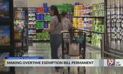
Will Alabama Lawmakers Cut Taxes on Overtime Pay or Groceries? | April 1, 2025 | News 19 at 6 p.m.
SUMMARY: Alabama lawmakers face a deadline to decide whether to extend the overtime pay tax exemption, set to expire at the end of June. Some lawmakers advocate making this exemption permanent, citing benefits for families. However, others argue that a grocery tax cut would impact a wider range of people, benefiting all consumers, not just those who work overtime. The grocery tax cut would reduce the state tax from 3% to 2%, saving about $1 per $100. Concerns about revenue loss from the overtime exemption and its impact on state funding, particularly education, complicate the decision.

The clock is ticking for some hourly workers in Alabama on whether or not any overtime they work would be taxed.
News 19 is North Alabama’s News Leader! We are the CBS affiliate in North Alabama and the Tennessee Valley since November 28, 1963.
https://whnt.com/
https://www.facebook.com/whntnews19
https://www.instagram.com/whntnews19/
https://twitter.com/whnt
News from the South - Alabama News Feed
Alabama Senate passes bill to ease log truck weighing delays
by Alander Rocha, Alabama Reflector
April 1, 2025
The Alabama State Senate passed a bill Tuesday aimed at improving efficiency in weighing log trucks.
SB 110, sponsored by Sen. Jack Williams, R-Wilmer, would limit the number of trucks that can be pulled over to five at roadside weigh stations. Previously, there was no limit, which caused long lines of trucks on the sides of highways and caused truckers to lose work hours.
“If you’re taking a day off being in court, and then they may put it off then when it gets there. So we’ve got a win-win. We just didn’t get the axle weight,” Williams said after the bill’s passage.
GET THE MORNING HEADLINES.
The bill passed 32-0 after senators removed a provision that would have increased weight limits for log truck drivers for each axle over concerns about damage to road infrastructure. Williams said that was a deal he accepted as early as Tuesday morning but that he’d try to address weight limits in the future.
The amendment, proposed by Sen. Clyde Chambliss, R-Prattville, would try to ease delays experienced by truck drivers, particularly those hauling logs, pointing to the possible economic impact of these delays.
“If you’re hung up on the side of the road for an hour, two hours, three hours, depending on how many trucks are backed up, well, you’ve lost money that day,” Chambliss said.
The bill also provides an appeals process for truck drivers who receive overweight citations based on portable scale measurements, aimed at addressing the potential of inaccurate portable scale readings.
While the bill aims to address efficiency and economic concerns, Williams said that weight limit issues, particularly concerning the hauling of 40-foot logs, require further attention. He said that logs cause more weights to be distributed unevenly between axles, causing drivers to haul fewer logs to comply with Alabama law.
“40-foot logs – that rear axle is going to get overloaded when you’ve got logs sticking all the way out there … if you’re hauling them legally, you’re hauling half a load of logs,” Williams said.
He said that weight limits were relaxed during the COVID pandemic, and he was not aware of any data that indicated roads were damaged during that time.
“That’s what I’d like to have back,” he said.
YOU MAKE OUR WORK POSSIBLE.
Alabama Reflector is part of States Newsroom, a nonprofit news network supported by grants and a coalition of donors as a 501c(3) public charity. Alabama Reflector maintains editorial independence. Contact Editor Brian Lyman for questions: info@alabamareflector.com.
The post Alabama Senate passes bill to ease log truck weighing delays appeared first on alabamareflector.com

Municipal primaries: Jackson Democrats head to runoff as suburbs gets answers

Pharmacy benefit manager reform likely dead

Northwest Florida Special Election results

Miami-Dade Commissioners vote to remove fluoride from drinking water

Will Alabama Lawmakers Cut Taxes on Overtime Pay or Groceries? | April 1, 2025 | News 19 at 6 p.m.

Election results: Key Illinois municipal races take shape

‘Historic’ Wisconsin spring election sees precincts run out of ballots | Wisconsin

Funding for program DC firefighters used in Potomac crash recovery under review | NBC4 Washington

Fixing the DMV: Latest on commissioner search, technology upgrades

Election results are trickling in

Family mourns death of 10-year-old Xavier Williams

Severe storms will impact Alabama this weekend. Damaging winds, hail, and a tornado threat are al…

University of Alabama student detained by ICE moved to Louisiana

Tornado watch, severe thunderstorm warnings issued for Oklahoma

Seafood testers find Shreveport restaurants deceiving customers with foreign shrimp

Why are Oklahomans smelling smoke Wednesday morning?

Roane County Schools installing security film on windows to protect students

Peanut farmer wants Florida water agency to swap forest land

Students in Monroe County Schools are ready to shoot their way to the WV State Archery Championships

Youngkin removes Ellis, appoints Cuccinelli to UVa board | Virginia
Northwest Florida Special Election results
Miami-Dade Commissioners vote to remove fluoride from drinking water
Will Alabama Lawmakers Cut Taxes on Overtime Pay or Groceries? | April 1, 2025 | News 19 at 6 p.m.
Election results: Key Illinois municipal races take shape
Funding for program DC firefighters used in Potomac crash recovery under review | NBC4 Washington
Fixing the DMV: Latest on commissioner search, technology upgrades
Election results are trickling in

Mother turns son's tragedy into mental health mission

Amendments coming to Houston's proposed short-term rentals ordinance

Louisiana Living: TaylorMade Teacakes
-

 News from the South - Florida News Feed6 days ago
Family mourns death of 10-year-old Xavier Williams
-
News from the South - Alabama News Feed5 days ago
Severe storms will impact Alabama this weekend. Damaging winds, hail, and a tornado threat are al…
-
 News from the South - Alabama News Feed4 days ago
University of Alabama student detained by ICE moved to Louisiana
-
News from the South - Oklahoma News Feed3 days ago
Tornado watch, severe thunderstorm warnings issued for Oklahoma
-
News from the South - Louisiana News Feed6 days ago
Seafood testers find Shreveport restaurants deceiving customers with foreign shrimp
-
News from the South - Oklahoma News Feed7 days ago
Why are Oklahomans smelling smoke Wednesday morning?
-
News from the South - West Virginia News Feed6 days ago
Roane County Schools installing security film on windows to protect students
-
News from the South - West Virginia News Feed7 days ago
Students in Monroe County Schools are ready to shoot their way to the WV State Archery Championships