News from the South - Louisiana News Feed
Good Morning San Antonio 5 a.m. : Oct 15, 2024
SUMMARY: “Good Morning San Antonio” begins with a live update from the city, noting the shift towards cooler fall temperatures as residents anticipate a cold front arriving tonight. The forecast anticipates highs near 97°F today, potentially breaking the previous record of 95°F, but will dip to 77°F by Wednesday. Traffic looks smooth with minor construction, while focus shifts to the investigation surrounding missing realtor Suzanne Simpson, with searches tied to a sealed warrant at a landfill. Additionally, early voting for the 2024 presidential election approaches, with measures being taken to assist deaf voters. San Antonio’s startup week is also highlighted.

The KSAT 12 News Team provides a look at local, regional, statewide and national news events and the latest information on local traffic and weather issues.


News from the South - Louisiana News Feed
Reproductive Justice Fund up for another San Antonio City Council vote Thursday
SUMMARY: The San Antonio City Council is set to vote on whether to allocate an additional $100,000 to the controversial Reproductive Justice Fund, originally designed to help cover travel costs for women seeking abortions. Although nearly half a million dollars in contracts were approved, none funded travel expenses, prompting renewed calls for more financial support. Some groups, like Beat AIDS Coalition Trust, are cautious about applying again, seeking legal assurances regarding abortion-related funding. Advocates emphasize the urgent need for funding, citing a crisis in Texas where women struggle to access abortion care amid ongoing legal challenges and restrictions.

The San Antonio City Council will vote Thursday morning on whether to put another $100,000 into a controversial health fund.
News from the South - Louisiana News Feed
Rep. Knox proposes tip tax exemption for Louisiana workers
SUMMARY: Rep. Alonzo Knox from New Orleans has introduced a bill to exempt tips from state income tax for Louisiana workers, aiming to provide tax relief to those in the hospitality industry, which supports 72,000 jobs in New Orleans. Many workers rely on tips, and Knox’s proposal would allow them to deduct tip income from their taxes. However, some experts, like Yon Mohler from Invest Louisiana, warn that this could reduce state revenue during challenging economic times and suggest implementing a meaningful state minimum wage instead. Knox anticipates bipartisan support for the bill, which targets individuals earning less than $65,000 annually.

Lawmakers are due back in Baton Rouge on April 14 for the start of this year’s regular session.
News from the South - Louisiana News Feed
Deadly shootings at phone repair shop add to concerns for neighbors
SUMMARY: A recent shootout at a San Antonio cell phone repair shop left two men dead, causing alarm among local residents. The incident involved 47-year-old Kenneth Mcnite Jr., who fatally shot employee Cody Bell, 35, before being killed by another worker. This violence adds to community fears following the unsolved murder of 28-year-old Maria Delles Labrador nearby. Residents express worry about safety, with some feeling the need to carry firearms for protection, particularly due to the proximity of violence to local establishments, including children’s swimming classes. The area is increasingly perceived as dangerous by locals.

A shooting at a cell phone repair shop on the far Northwest Side Tuesday afternoon is adding to concerns that people who live in the area already had.

Reproductive Justice Fund up for another San Antonio City Council vote Thursday

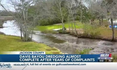
Davis Bayou dredging almost finished after years of complaints

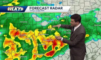
St. Louis forecast: Flash flooding possible Friday, Saturday

2 of 6 charged in shooting death of 7-year-old Breon Allen expected to plead not guilty on Thursday

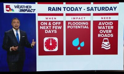
Flooding rain and storms expected through the weekend

Here’s the one Nashville chef named a finalist for the coveted James Beard Award

Journalists in Haiti defy bullets and censorship to cover unprecedented violence

Measles can ravage the immune system and brain, causing long-term damage – a virologist explains

New Tariffs Could Raise Car Prices | April 2, 2025 | News 19 at 10 p.m.

Miami businesses prepare to absorb costs amid new tariffs

Pharmacy benefit manager reform likely dead

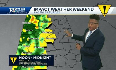
Severe storms will impact Alabama this weekend. Damaging winds, hail, and a tornado threat are al…

University of Alabama student detained by ICE moved to Louisiana

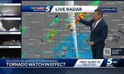
Tornado watch, severe thunderstorm warnings issued for Oklahoma

Youngkin removes Ellis, appoints Cuccinelli to UVa board | Virginia

A little early morning putting at the PGA Tour Superstore

Georgia road project forcing homeowners out | FOX 5 News

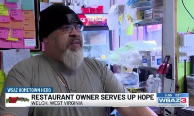
Hometown Hero | Restaurant owner serves up hope

Artificial intelligence experiment begins in North Carolina treasurer’s office | North Carolina

Budget cuts: Senior Citizens Inc. and other non-profits worry for the future
Reproductive Justice Fund up for another San Antonio City Council vote Thursday
Davis Bayou dredging almost finished after years of complaints
St. Louis forecast: Flash flooding possible Friday, Saturday
Flooding rain and storms expected through the weekend
New Tariffs Could Raise Car Prices | April 2, 2025 | News 19 at 10 p.m.
Miami businesses prepare to absorb costs amid new tariffs

Weather Fun 1on1: Brylee explains why thunderstorms occur more often in the summer than in the wi…

Mobile defendants sentenced to life in prison for murder-for-hire conspiracy

3 killed in fiery Lexington crash temporarily shuts down portion of New Circle Road

UMD introduces Buzz Williams as new men’s basketball coach | NBC4 Washington
-

 Mississippi Today1 day ago
Pharmacy benefit manager reform likely dead
-
News from the South - Alabama News Feed7 days ago
Severe storms will impact Alabama this weekend. Damaging winds, hail, and a tornado threat are al…
-
 News from the South - Alabama News Feed6 days ago
University of Alabama student detained by ICE moved to Louisiana
-
News from the South - Oklahoma News Feed4 days ago
Tornado watch, severe thunderstorm warnings issued for Oklahoma
-
 News from the South - Virginia News Feed6 days ago
Youngkin removes Ellis, appoints Cuccinelli to UVa board | Virginia
-
News from the South - Kentucky News Feed7 days ago
A little early morning putting at the PGA Tour Superstore
-
News from the South - Georgia News Feed5 days ago
Georgia road project forcing homeowners out | FOX 5 News
-
News from the South - West Virginia News Feed5 days ago
Hometown Hero | Restaurant owner serves up hope