News from the South - Alabama News Feed
Saturday Morning Weather – 10/5/24
SUMMARY: Today’s weather forecast indicates a sunny and warm day across Athens and Huntsville, with temperatures reaching the upper 80s to near 90 degrees. Early morning may bring patchy, dense fog, so caution is advised for drivers. There’s no rain expected for college football games this afternoon, with temperatures starting in the upper 80s and cooling to the low 70s by evening. A cold front will move in on Monday, bringing cooler temperatures in the 70s and lows in the 40s for the upcoming week. Expect dry and sunny conditions overall for the next seven days.
Saturday Morning Weather – 10/5/24.


News from the South - Alabama News Feed
How to Get Your Home Ready for the Winter | Nov. 21, 2024 | News 19 at 6 p.m.
SUMMARY: As temperatures drop in the Tennessee Valley, many are experiencing issues with their heating systems, prompting concerns about burning smells. This is often due to dust buildup, which is typically harmless if it dissipates within 5 to 10 minutes. To avoid heating problems, experts recommend scheduling a system tune-up and ensuring that all entrances have proper weather stripping to prevent heat loss. Regularly replacing air filters also helps maintain the system’s efficiency. For energy savings, the U.S. Department of Energy suggests setting thermostats as low as comfortably possible.
With the drop in temperatures, comes an increase in the number of people cranking up the heat for the first time since last winter.
News 19 is North Alabama’s News Leader! We are the CBS affiliate in North Alabama and the Tennessee Valley since November 28, 1963.
https://whnt.com/
https://www.facebook.com/whntnews19
https://www.instagram.com/whntnews19/
https://twitter.com/whnt
News from the South - Alabama News Feed
New funding from the state helps domestic violence victims in Mobile
SUMMARY: New funding efforts in South Alabama aim to combat domestic violence with a nearly $330,000 grant from the U.S. Department of Health and Human Services. Three organizations, including Penelope House, Lifelines Family Counseling Center, and Baldwin Family Violence Shelter, will utilize this funding to raise awareness and educate the community, particularly schools, about healthy versus unhealthy relationships. In 2023, Mobile recorded over 3,000 domestic violence assaults and eight homicides, highlighting the urgent need for preventative measures. The initiative focuses on teaching young people about relationship boundaries and available resources to support victims.
A grant of nearly $329000 will be going towards prevention of domestic violence, for three local organizations that serve victims in …
SUMMARY: Following a mass shooting in the Five Points South District that left four dead and 17 injured on September 21, restaurant sales plummeted by 80% for some. However, business owner Ace Graham noted improvements in sales two months later, coinciding with seasonal changes and increased community spending. Despite this positive trend, the nearby Hush Lounge has announced its closure, reflecting the ongoing challenges for small businesses in the area. Graham remains optimistic, believing that community events, like the upcoming Saint Patrick’s Day parade, will help rejuvenate the entertainment district and foster local growth.
Hush Lounge set to close months after mass shooting Subscribe to WVTM on YouTube now for more: https://bit.ly/2jvAaUD Get …

Law enforcement agencies slam Bexar County sheriff’s policy that rejects certain inmates from jail

Documents allege Oklahoma church coverup of man accused of sexually assaulting children

Cool morning, Warm afternoon, then a Thanksgiving cold front

Long Beach amends lease to begin process for developing casino

How to Get Your Home Ready for the Winter | Nov. 21, 2024 | News 19 at 6 p.m.

Abbott directs state agencies to divest from investments originating from China | Texas

Study: AI and data centers could drive cost of energy up by 70% over 10 years | Virginia

Mississippi College, Delta State players earn postseason football honors

New funding from the state helps domestic violence victims in Mobile

2 arrests made in connection to DeKalb County Jail

Create Art from Molten Metal: Southern Miss Sculpture to Host Annual Interactive Iron Pour

Celebrate the holidays in Ocean Springs with free, festive activities for the family

'Hunting for females' | First day of trial in Laken Riley murder reveals evidence not seen yet

First woman installed as commanding officer of NAS Pensacola

A Closely Watched Trial Over Idaho’s Near-Total Abortion Ban Continues Tuesday

On this day in 1972

Trial underway for Sheila Agee, the mother accused in deadly Home Depot shooting

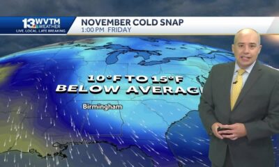
Alabama's weather forecast is getting colder, and a widespread frost and freeze is likely by the …

Jose Ibarra found guilty in murder of Laken Riley | FOX 5 News

Habitat Restoration Can Appear Messy
Law enforcement agencies slam Bexar County sheriff’s policy that rejects certain inmates from jail
Documents allege Oklahoma church coverup of man accused of sexually assaulting children
Cool morning, Warm afternoon, then a Thanksgiving cold front
How to Get Your Home Ready for the Winter | Nov. 21, 2024 | News 19 at 6 p.m.
New funding from the state helps domestic violence victims in Mobile
2 arrests made in connection to DeKalb County Jail

Florida man survives killer bee attack while trimming trees: 'Pain was just excruciating'

Serial killer could be tied to Nashville cold case

Sex allegations mount against pediatrician; former patient speaks out

Hush Lounge set to close months after mass shooting
-
 Our Mississippi Home7 days ago
Create Art from Molten Metal: Southern Miss Sculpture to Host Annual Interactive Iron Pour
-
 Local News6 days ago
Celebrate the holidays in Ocean Springs with free, festive activities for the family
-
 News from the South - Georgia News Feed6 days ago
'Hunting for females' | First day of trial in Laken Riley murder reveals evidence not seen yet
-
 News from the South - Alabama News Feed7 days ago
First woman installed as commanding officer of NAS Pensacola
-
 Kaiser Health News4 days ago
A Closely Watched Trial Over Idaho’s Near-Total Abortion Ban Continues Tuesday
-
 Mississippi Today6 days ago
On this day in 1972
-
 News from the South - Alabama News Feed2 days ago
Trial underway for Sheila Agee, the mother accused in deadly Home Depot shooting
-
 News from the South - Alabama News Feed2 days ago
Alabama's weather forecast is getting colder, and a widespread frost and freeze is likely by the …