Connect with us

The Conversation

Want to solve a complex problem? Applied math can help

Published

on

theconversation.com – Alan Veliz-Cuba, Associate Professor of Mathematics, University of Dayton – 2024-10-01 07:25:00

Applied mathematicians use math to model real-world situations.
Ariel Skelley/DigitalVision via Getty Images

Alan Veliz-Cuba, University of Dayton

You can probably think of a time when you’ve used math to solve an everyday problem, such as calculating a tip at a restaurant or determining the square footage of a room. But what role does math play in solving complex problems such as curing a disease?

In my job as an applied mathematician, I use mathematical tools to study and solve complex problems in biology. I have worked on problems involving gene and neural networks such as interactions between cells and decision-making. To do this, I create descriptions of a real-world situation in mathematical language. The act of turning a situation into a mathematical representation is called modeling.

Translating real situations into mathematical terms

If you ever solved an arithmetic problem about the speed of trains or cost of groceries, that’s an example of mathematical modeling. But for more difficult questions, even just writing the real-world scenario as a math problem can be complicated. This process requires a lot of creativity and understanding of the problem at hand and is often the result of applied mathematicians working with scientists in other disciplines.

A group of researchers conversing around a conference table.
Applied mathematicians collaborate with scientists in other fields to answer a wide variety of questions.
Hinterhaus Productions/DigitalVision via Getty Images

As an example, we could represent a game of Sudoku as a mathematical model. In Sudoku, the player fills empty boxes in a puzzle with numbers between 1 and 9 subject to some rules, such as no repeated numbers in any row or column.

The puzzle begins with some prefilled boxes, and the goal is to figure out which numbers go in the rest of the boxes.

Imagine that a variable, say x, represents the number that goes in one of those empty boxes. We can guarantee that x is between 1 and 9 by saying that x solves the equation (x-1)(x-2) … (x-9)=0. This equation is true only when one of the factors on the left side is zero. Each of the factors on the left side is zero only when x is a number between 1 and 9; for example, (x-1)=0 when x=1. This equation encodes a fact about our game of Sudoku, and we can encode the other features of the game similarly. The resulting model of Sudoku will be a set of equations with 81 variables, one for each box in the puzzle.

Another situation we might model is the concentration of a drug, say aspirin, in a person’s bloodstream. In this case, we would be interested in how the concentration changes as we ingest aspirin and the body metabolizes it. Just like with Sudoku, one can create a set of equations that describe how the concentration of aspirin evolves over time and how additional ingestion affects the dynamics of this medication. In contrast to Sudoku, however, the variables that represent concentrations are not static but rather change over time.

A pen resting on a sudoku puzzle in a newspaper.
Sudoku is an example of a situation that can be modeled mathematically.
Peter Dazeley/The Image Bank via Getty Images

But the act of modeling is not always so straightforward. How would we model diseases such as cancer? Is it enough to model the size and shape of a tumor, or do we need to model every single blood vessel inside the tumor? Every single cell? Every single chemical in each cell? There is much that is unknown about cancer, so how can we model such unknown features? Is it even possible?

Applied mathematicians have to find a balance between models that are realistic enough to be useful and simple enough to be implemented. Building these models may take several years, but in collaboration with experimental scientists, the act of trying to find a model often provides novel insight into the real-world problem.

Mathematical models help find real solutions

After writing a mathematical problem to represent a situation, the second step in the modeling process is to solve the problem.

For Sudoku, we need to solve a collection of equations with 81 variables. For the aspirin example, we need to solve an equation that describes the rate of change of concentrations. This is where all the math that has been and is still being invented comes into play. Areas of pure math such as algebra, analysis, combinatorics and many others can be used – in some cases combined – to solve the complex math problems arising from applications of math to the real world.

The third step of the modeling process consists of translating the mathematical solution into the solution to the applied problem. In the case of Sudoku, the solution to the equations tells us which number should go in each box to solve the puzzle. In the case of aspirin, the solution would be a set of curves that tell us the aspirin concentration in the digestive system and bloodstream. This is how applied mathematics works.

When creating a model isn’t enough

Or is it? While this three-step process is the ideal process of applied math, reality is more complicated. Once I reach the second step where I want the solution of the math problem, very often, if not most of the time, it turns out that no one knows how to solve the math problem in the model. In some cases, the math to study the problem doesn’t even exist.

For example, it is difficult to analyze models of cancer because the interactions between genes, proteins and chemicals are not as straightforward as the relationships between boxes in a game of Sudoku. The main difficulty is that these interactions are “nonlinear,” meaning that the effect of two inputs is not simply the sum of the individual effects. To address this, I have been working on novel ways to study nonlinear systems, such as Boolean network theory and polynomial algebra. With this and traditional approaches, my colleagues and I have studied questions in areas such as
decision-making,
gene networks,
cellular differentiation and
limb regeneration.

When approaching unsolved applied math problems, the distinction between applied and pure mathematics often vanishes. Areas that were considered at one time too abstract have been exactly what is needed for modern problems. This highlights the importance of math for all of us; current areas of pure mathematics can become the applied mathematics of tomorrow and be the tools needed for complex, real-world problems.The Conversation

Alan Veliz-Cuba, Associate Professor of Mathematics, University of Dayton

This article is republished from The Conversation under a Creative Commons license. Read the original article.

Read More

The post Want to solve a complex problem? Applied math can help appeared first on theconversation.com

The Conversation

Wildfire smoke’s health risks can linger long-term in homes that escape burning

Published

on

theconversation.com – Colleen E. Reid, Associate Professor of Geography, University of Colorado Boulder – 2024-12-23 11:00:00

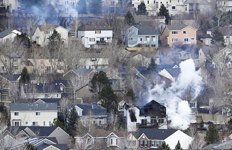
The Marshall Fire spared some homes, shown here a day later, but smoke had blanketed the area.

Andy Cross/MediaNews Group/The Denver Post via Getty Images

Colleen E. Reid, University of Colorado Boulder

Three years ago, on Dec. 30, 2021, a wind-driven wildfire raced through two communities just outside Boulder, Colorado. In the span of about eight hours, more than 1,000 homes and businesses burned.

The fire left entire blocks in ash, but among them, pockets of houses survived, seemingly untouched. The owners of these homes may have felt relief at first. But fire damage can be deceiving, as many soon discovered.

When wildfires like the Marshall Fire reach the wildland-urban interface, they are burning both vegetation and human-made materials. Vehicles and buildings burn, along with all of the things inside them – electronics, paint, plastics, furniture.

Research shows that when human-made materials like these burn, the chemicals released are different from what is emitted when just vegetation burns. The smoke and ash can blow under doors and around windows in nearby homes, bringing in chemicals that stick to walls and other indoor surfaces and continue off-gassing for weeks to months, particularly in warmer temperatures.

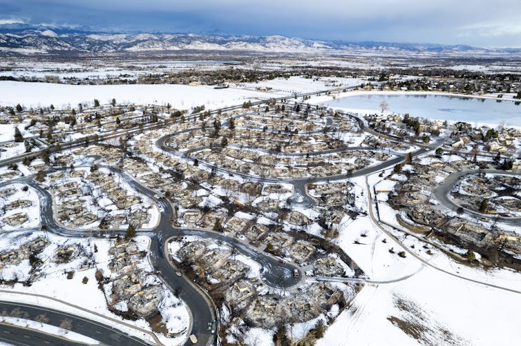
An aerial view of burned neighborhoods with a few houses standing among burned lots and at the edges of the fire area.

The Marshall Fire swept through several neighborhoods in the towns of Louisville and Superior, Colo. In the homes that were left standing, residents dealt with lingering smoke and ash in their homes.

Michael Ciaglo/Getty Images

In a new study, my colleagues and I looked at the health effects people experienced when they returned to still-standing homes after the Marshall Fire. We also created a checklist for people to use after urban wildfires in the future to help them protect their health and reduce their risks when they return to smoke-damaged homes.

Tests in homes found elevated metals and VOCs

In the days after the Marshall Fire, residents quickly reached out to nearby scientists who study wildfire smoke and health risks at the University of Colorado Boulder and area labs. People wanted to know what was in the ash and causing the lingering smells inside their homes.

In homes we were able to test, my colleagues found elevated levels of metals and PAHs – polycyclic aromatic hydrocarbons – in the ash. We also found elevated VOCs – volatile organic compounds – in airborne samples. Some VOCs, such as dioxins, benzene, formaldehyde and PAHs, can be toxic to humans. Benzene is a known carcinogen.

People wanted to know whether the chemicals that got into their homes that day could harm their health.

At the time, we could find no information about physical health implications for people who have returned to smoke-damaged homes after a wildfire. To look for patterns, we surveyed residents affected by the fire six months, one year and two years afterward.

Symptoms 6 months after the fire

Even six months after the fire, we found that many people were reporting symptoms that aligned with health risks related to smoke and ash from fires.

More than half (55%) of the people who responded to our survey reported that they were experiencing at least one symptom six months after the blaze that they attributed to the Marshall Fire. The most common symptoms reported were itchy or watery eyes (33%), headache (30%), dry cough (27%), sneezing (26%) and sore throat (23%).

All of these symptoms, as well as having a strange taste in one’s mouth, were associated with people reporting that their home smelled differently when they returned to it one week after the fire.

Many survey respondents said that the smells decreased over time. Most attributed the improvement in smell to the passage of time, cleaning surfaces and air ducts, replacing furnace filters, and removing carpet, textiles and furniture from the home. Despite this, many still had symptoms.

We found that living near a large number of burned structures was associated with these health symptoms. For every 10 additional destroyed buildings within 820 feet (250 meters) of a person’s home, there was a 21% increase in headaches and a 26% increase in having a strange taste in their mouth.

These symptoms align with what could be expected from exposure to the chemicals that we found in the ash and measured in the air inside the few smoke-damaged homes that we were able to study in depth.

Lingering symptoms and questions

There are a still a lot of unanswered questions about the health risks from smoke- and ash-damaged homes.

For example, we don’t yet know what long-term health implications might look like for people living with lingering gases from wildfire smoke and ash in a home.

We found a significant decline in the number of people reporting symptoms one year after the fire. However, 33% percent of the people whose homes were affected still reported at least one symptom that they attributed to the fire. About the same percentage also reported at least one symptom two years after the fire.

We also could not measure the level of VOCs or metals that each person was exposed to. But we do think that reports of a change in the smell of a person’s home one week after the fire demonstrates the likely presence of VOCs in the home. That has health implications for people whose homes are exposed to smoke or ash from a wildfire.

Tips to protect yourself after future wildfires

Wildfires are increasingly burning homes and other structures as more people move into the wildland-urban interface, temperatures rise and fire seasons lengthen.

It can be confusing to know what to do if your home is one that survives a wildfire nearby. To help, my colleagues and I put together a website of steps to take if your home is ever infiltrated by smoke or ash from a wildfire.

Here are a few of those steps:

  • When you’re ready to clean your home, start by protecting yourself. Wear at least an N95 (or KN95) mask and gloves, goggles and clothing that covers your skin.

  • Vacuum floors, drapes and furniture. But avoid harsh chemical cleaners because they can react with the chemicals in the ash.

  • Clean your HVAC filter and ducts to avoid spreading ash further. Portable air cleaners with carbon filters can help remove VOCs.

A recent scientific study documents how cleaning all surfaces within a home can reduce reservoirs of VOCs and lower indoor air concentrations of VOCs.

Given that we don’t know much yet about the health harms of smoke- and ash-damaged homes, it is important to take care in how you clean so you can do the most to protect your health.The Conversation

Colleen E. Reid, Associate Professor of Geography, University of Colorado Boulder

This article is republished from The Conversation under a Creative Commons license. Read the original article.

Read More

The post Wildfire smoke’s health risks can linger long-term in homes that escape burning appeared first on theconversation.com

Continue Reading

The Conversation

In Disney’s ‘Moana,’ the characters navigate using the stars, just like real Polynesian explorers − an astronomer explains how these methods work

Published

on

theconversation.com – Christopher Palma, Teaching Professor, Department of Astronomy & Astrophysics, Penn State – 2024-12-20 07:17:00

Wayfarers around the world have used the stars to navigate the sea.
Wirestock/iStock via Getty Images Plus

Christopher Palma, Penn State

If you have visited an island like one of the Hawaiian Islands, Tahiti or Easter Island, also known as Rapa Nui, you may have noticed how small these land masses appear against the vast Pacific Ocean. If you’re on Hawaii, the nearest island to you is more than 1,000 miles (1,600 kilometers) away, and the coast of the continental United States is more than 2,000 miles (3,200 kilometers) away. To say these islands are secluded is an understatement.

For me, watching the movie “Moana” in 2016 was eye-opening. I knew that Polynesian people traveled between a number of Pacific islands, but seeing Moana set sail on a canoe made me realize exactly how small those boats are compared with what must have seemed like an endless ocean. Yet our fictional hero went on this journey anyway, like the countless real-life Polynesian voyagers upon which she is based.

Oceania as shown from the ISS
Islands in Polynesia can be thousands of miles apart.
NASA

As an astronomer, I have been teaching college students and visitors to our planetarium how to find stars in our sky for more than 20 years. As part of teaching appreciation for the beauty of the sky and the stars, I want to help people understand that if you know the stars well, you can never get lost.

U.S. Navy veterans learned the stars in their navigation courses, and European cultures used the stars to navigate, but the techniques of Polynesian wayfinding shown in Moana brought these ideas to a very wide audience.

The movie Moana gave me a new hook – pun not intended – for my planetarium shows and lessons on how to locate objects in the night sky. With “Moana 2” out now, I am excited to see even more astronomy on the big screen and to figure out how I can build new lessons using the ideas in the movie.

The North Star

Have you ever found the North Star, Polaris, in your sky? I try to spot it every time I am out observing, and I teach visitors at my shows to use the “pointer stars” in the bowl of the Big Dipper to find it. These two stars in the Big Dipper point you directly to Polaris.

If you are facing Polaris, then you know you are facing north. Polaris is special because it is almost directly above Earth’s North Pole, and so everyone north of the equator can see it year-round in exactly the same spot in their sky.

It’s a key star for navigation because if you measure its height above your horizon, that tells you how far you are north of Earth’s equator. For the large number of people who live near 40 degrees north of the equator, you will see Polaris about 40 degrees above your horizon.

If you live in northern Canada, Polaris will appear higher in your sky, and if you live closer to the equator, Polaris will appear closer to the horizon. The other stars and constellations come and go with the seasons, though, so what you see opposite Polaris in the sky will change every month.

Look for the Big Dipper to find the North Star, Polaris.

You can use all of the stars to navigate, but to do that you need to know where to find them on every night of the year and at every hour of the night. So, navigating with stars other than Polaris is more complicated to learn.

Maui’s fishhook

At the end of June, around 11 p.m., a bright red star might catch your eye if you look directly opposite from Polaris. This is the star Antares, and it is the brightest star in the constellation Scorpius, the Scorpion.

If you are a “Moana” fan like me and the others in my family, though, you may know this group of stars by a different name – Maui’s fishhook.

If you are in the Northern Hemisphere, Scorpius may not fully appear above your horizon, but if you are on a Polynesian island, you should see all of the constellation rising in the southeast, hitting its highest point in the sky when it is due south, and setting in the southwest.

Astronomers and navigators can measure latitude using the height of the stars, which Maui and Moana did in the movie using their hands as measuring tools.

The easiest way to do this is to figure out how high Polaris is above your horizon. If you can’t see it at all, you must be south of the equator, but if you see Polaris 5 degrees (the width of three fingers at arm’s length) or 10 degrees above your horizon (the width of your full fist held at arm’s length), then you are 5 degrees or 10 degrees north of the equator.

The other stars, like those in Maui’s fishhook, will appear to rise, set and hit their highest point at different locations in the sky depending on where you are on the Earth.

Polynesian navigators memorized where these stars would appear in the sky from the different islands they sailed between, and so by looking for those stars in the sky at night, they could determine which direction to sail and for how long to travel across the ocean.

Today, most people just pull out their phones and use the built-in GPS as a guide. Ever since “Moana” was in theaters, I see a completely different reaction to my planetarium talks about using the stars for navigation. By accurately showing how Polynesian navigators used the stars to sail across the ocean, Moana helps even those of us who have never sailed at night to understand the methods of celestial navigation.

The first “Moana” movie came out when my son was 3 years old, and he took an instant liking to the songs, the story and the scenery. There are many jokes about parents who dread having to watch a child’s favorite over and over again, but in my case, I fell in love with the movie too.

Since then, I have wanted to thank the storytellers who made this movie for being so careful to show the astronomy of navigation correctly. I also appreciated that they showed how Polynesian voyagers used the stars and other clues, such as ocean currents, to sail across the huge Pacific Ocean and land safely on a very small island thousands of miles from their home.The Conversation

Christopher Palma, Teaching Professor, Department of Astronomy & Astrophysics, Penn State

This article is republished from The Conversation under a Creative Commons license. Read the original article.

Read More

The post In Disney’s ‘Moana,’ the characters navigate using the stars, just like real Polynesian explorers − an astronomer explains how these methods work appeared first on theconversation.com

Continue Reading

The Conversation

Listening for the right radio signals could be an effective way to track small drones

Published

on

theconversation.com – Iain Boyd, Director of the Center for National Security Initiatives and Professor of Aerospace Engineering Sciences, University of Colorado Boulder – 2024-12-17 17:28:00

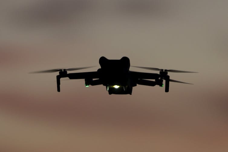
Small drones can be hard to track at night.
Kevin Carter/Getty Images

Iain Boyd, University of Colorado Boulder

The recent spate of unidentified drone sightings in the U.S., including some near sensitive locations such as airports and military installations, has caused significant public concern.

Some of this recent increase in activity may be related to a September 2023 change in U.S. Federal Aviation Administration regulations that now allow drone operators to fly at night. But most of the sightings are likely airplanes or helicopters rather than drones.

The inability of the U.S. government to definitively identify the aircraft in the recent incidents, however, has some people wondering, why can’t they?

I am an engineer who studies defense systems. I see radio frequency sensors as a promising approach to detecting, tracking and identifying drones, not least because drone detectors based on the technology are already available. But I also see challenges to using the detectors to comprehensively spot drones flying over American communities.

How drones are controlled

Operators communicate with drones from a distance using radio frequency signals. Radio frequency signals are widely used in everyday life such as in garage door openers, car key fobs and, of course, radios. Because the radio spectrum is used for so many different purposes, it is carefully regulated by the Federal Communications Commission.

Drone communications are only allowed in narrow bands around specific frequencies such as at 5 gigahertz. Each make and model of a drone uses unique communication protocols coded within the radio frequency signals to interpret instructions from an operator and to send data back to them. In this way, a drone pilot can instruct the drone to execute a flight maneuver, and the drone can inform the pilot where it is and how fast it is flying.

Identifying drones by radio signals

Radio frequency sensors can listen in to the well-known drone frequencies to detect communication protocols that are specific to each particular drone model. In a sense, these radio frequency signals represent a unique fingerprint of each type of drone.

In the best-case scenario, authorities can use the radio frequency signals to determine the drone’s location, range, speed and flight direction. These radio frequency devices are called passive sensors because they simply listen out for and receive signals without taking any active steps. The typical range limit for detecting signals is about 3 miles (4.8 kilometers) from the source.

These sensors do not represent advanced technology, and they are readily available. So, why haven’t authorities made wider use of them?

Drones were all the buzz in the Northeast at the end of 2024.

Challenges to using radio frequency sensors

While the monitoring of radio frequency signals is a promising approach to detecting and identifying drones, there are several challenges to doing so.

First, it’s only possible for a sensor to obtain detailed information on drones that the sensor knows the communication protocols for. Getting sensors that can detect a wide range of drones will require coordination between all drone manufacturers and some central registration entity.

In the absence of information that makes it possible to decode the radio frequency signals, all that can be inferred about a drone is a rough idea of its location and direction. This situation can be improved by deploying multiple sensors and coordinating their information.

Second, the detection approach works best in “quiet” radio frequency environments where there are no buildings, machinery or people. It’s not easy to confidently attribute the unique source of a radio frequency signal in urban settings and other cluttered environments. Radio frequency signals bounce off all solid surfaces, making it difficult to be sure where the original signal came from. Again, the use of multiple sensors around a particular location, and careful placement of those sensors, can help to alleviate this issue.

Third, a major part of the concern over the inability to detect and identify drones is that they may be operated by criminals or terrorists. If drone operators with malicious intent know that an area targeted for a drone operation is being monitored by radio frequency sensors, they may develop effective countermeasures. For example, they may use signal frequencies that lie outside the FCC-regulated parameters, and communication protocols that have not been registered. An even more effective countermeasure is to preprogram the flight path of a drone to completely avoid the use of any radio frequency communications between the operator and the drone.

Finally, widespread deployment of radio frequency sensors for tracking drones would be logistically complicated and financially expensive. There are likely thousands of locations in the U.S. alone that might require protection from hostile drone attacks. The cost of deploying a fully effective drone detection system would be significant.

There are other means of detecting drones, including radar systems and networks of acoustic sensors, which listen for the unique sounds drones generate. But radar systems are relatively expensive, and acoustic drone detection is a new technology.

The way forward

It was almost guaranteed that at some point the problem of unidentified drones would arise. People are operating drones more and more in regions of the airspace that have previously been very sparsely populated.

Perhaps the recent concerns over drone sightings are a wake-up call. The airspace is only going to become much more congested in the coming years as more consumers buy drones, drones are used for more commercial purposes, and air-taxis come into use. There’s only so much that drone detection technologies can do, and it might become necessary for the FAA to tighten regulation of the nation’s airspace by, for example, requiring drone operators to submit detailed flight plans.

In the meantime, don’t be too quick to assume those blinking lights you see in the night sky are drones.The Conversation

Iain Boyd, Director of the Center for National Security Initiatives and Professor of Aerospace Engineering Sciences, University of Colorado Boulder

This article is republished from The Conversation under a Creative Commons license. Read the original article.

Read More

The post Listening for the right radio signals could be an effective way to track small drones appeared first on theconversation.com

Continue Reading

Trending