News from the South - Louisiana News Feed
Monday 5 AM Tropical Update: Watching the Gulf this week for development
SUMMARY: The tropics are active, with a new area to monitor as we approach the end of the week. While we don’t expect it to develop into a significant storm like Hurricane Helen, the potential for a weak low pressure system exists. Rain is likely by Thursday and Friday, with moisture lingering in the Gulf through the weekend. Models are uncertain, but there’s a 50/50 chance of a tropical depression or storm forming. Meanwhile, other tropical systems, including Hurricanes Isaac and Joyce, are developing. October is historically busy for hurricanes, and we will continue monitoring conditions closely.
We kick off the week and last day of September with warm and dry weather. The next few days stay dry with warm afternoons near 90 degrees.
By Thursday, tropical moisture moves in from the Gulf of Mexico leading to scattered rain and storms Thursday and Friday. As increasing moisture and disturbed weather enters the Gulf this week, further development is possible which is something that will need to be monitored all this week. So far, the big global models are backing down on developing anything significant which is a good thing. It is too soon to know what will play out so be sure to stay tuned. At this point, plan for more rain and storms on Thursday and Friday, with some lingering showers into early next weekend. It may be occasionally breezy too later this week with high temperatures in the low to mid 80s.


News from the South - Louisiana News Feed
Law enforcement agencies slam Bexar County sheriff’s policy that rejects certain inmates from jail
SUMMARY: Bear County law enforcement agencies express concern over a new booking policy by Sheriff Javier Salazar, which delays jail intake for suspects requiring medical screening. The directive, aimed at addressing jail deaths, mandates that suspects detoxing from substances or with serious medical conditions must be evaluated at a hospital before booking. This has led to significant delays and complications for officers, with reports of suspects being released instead of booked. Smaller agencies worry that the policy jeopardizes public safety. Despite the concerns raised, Sheriff Salazar maintains that the policy is necessary to improve health outcomes for detainees.
Several area law enforcement agencies said a new directive from Bexar County Sheriff Javier Salazar puts public safety at risk.
News from the South - Louisiana News Feed
Thursday 5PM First Weather: Few degrees colder next two mornings
SUMMARY: Chilly air has settled in, and temperatures are expected to drop further tonight and into the weekend. Chief meteorologist Chris Franklin reports that temperatures will be a few degrees colder, with widespread 30s on the North Shore and 50s in the metro area. Clear skies have resulted in high temperatures staying below average, with daytime highs in the 60s. The colder air might allow North Shore areas to reach the 30s and create patchy frost by Saturday morning. Chris will provide updates on how long this cold spell will last as Thanksgiving approaches.
WWL Louisiana Chief Meteorologist Chris Franklin with a first look at New Orleans-area forecast for Thursday, Nov. 21, 2024.
SUMMARY: New Orleans police are investigating a deadly shooting near the intersection of Iberville and Royal Streets in the French Quarter, where four people were shot, one fatally. The shooting occurred around 12:30 PM and follows a recent mass shooting in the Saint Roch neighborhood. Authorities are still gathering details. Meanwhile, families are preparing for Thanksgiving, with some small savings expected for the holiday dinner this year. Updates on both stories are being provided on air and online.
Four shot, 1 dead in French Quarter shooting
Subscribe to WDSU on YouTube now for more: http://bit.ly/1n00vnY
Get more New Orleans news: http://www.wdsu.com
Like us: http://www.facebook.com/wdsutv
Follow us: http://twitter.com/wdsu
Instagram: https://www.instagram.com/wdsu6/

On this day in 1961

How Trump’s mass deportation plans could impact Florida

Texas lawmaker makes push to remove death penalty in the state | FOX 7 Austin

Meridian native Rodney Hood announces retirement from NBA

Why did Biltmore remove the beautiful old trees at its main gate? Lead flushing necessary at apartment buildings? City water has a ‘swampy’ smell to it? • Asheville Watchdog

Readers Embrace ‘Going It Alone’ Series on Aging and Chastise Makers of Pulse Oximeters

Georgians With Disabilities Are Still Being Institutionalized, Despite Federal Oversight

Salvation Army partners with local businesses to host Hurricane Victims Benefit Concert in Downto…

Minimal rainfall brings mixed bag

Care Center Ministries helps through Turkey Drive 16

Create Art from Molten Metal: Southern Miss Sculpture to Host Annual Interactive Iron Pour

Celebrate the holidays in Ocean Springs with free, festive activities for the family

'Hunting for females' | First day of trial in Laken Riley murder reveals evidence not seen yet

First woman installed as commanding officer of NAS Pensacola

A Closely Watched Trial Over Idaho’s Near-Total Abortion Ban Continues Tuesday

On this day in 1972

Trial underway for Sheila Agee, the mother accused in deadly Home Depot shooting

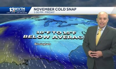
Alabama's weather forecast is getting colder, and a widespread frost and freeze is likely by the …

Jose Ibarra found guilty in murder of Laken Riley | FOX 5 News

Habitat Restoration Can Appear Messy
How Trump’s mass deportation plans could impact Florida
Texas lawmaker makes push to remove death penalty in the state | FOX 7 Austin
Salvation Army partners with local businesses to host Hurricane Victims Benefit Concert in Downto…
Minimal rainfall brings mixed bag
Care Center Ministries helps through Turkey Drive 16

Law enforcement agencies slam Bexar County sheriff’s policy that rejects certain inmates from jail

Documents allege Oklahoma church coverup of man accused of sexually assaulting children

Nearly 1,000 Amazon trucks sent to Humble warehouse in dispatching glitch, police say

Cool morning, Warm afternoon, then a Thanksgiving cold front

How to Get Your Home Ready for the Winter | Nov. 21, 2024 | News 19 at 6 p.m.
-
 Our Mississippi Home7 days ago
Create Art from Molten Metal: Southern Miss Sculpture to Host Annual Interactive Iron Pour
-
 Local News6 days ago
Celebrate the holidays in Ocean Springs with free, festive activities for the family
-
 News from the South - Georgia News Feed6 days ago
'Hunting for females' | First day of trial in Laken Riley murder reveals evidence not seen yet
-
 News from the South - Alabama News Feed7 days ago
First woman installed as commanding officer of NAS Pensacola
-
 Kaiser Health News4 days ago
A Closely Watched Trial Over Idaho’s Near-Total Abortion Ban Continues Tuesday
-
 Mississippi Today6 days ago
On this day in 1972
-
 News from the South - Alabama News Feed3 days ago
Trial underway for Sheila Agee, the mother accused in deadly Home Depot shooting
-
 News from the South - Alabama News Feed2 days ago
Alabama's weather forecast is getting colder, and a widespread frost and freeze is likely by the …