News from the South - Louisiana News Feed
Weekend Weather: Saturday, August 3
SUMMARY: This weekend will be extremely hot, with excessive heat warnings in effect and temperatures feeling like 115°F in some areas. Scattered showers and storms are possible today due to a cold front moving south, but the work week ahead is expected to be mostly dry. Meanwhile, tropical depression 4 is strengthening and will likely become tropical storm Debbie, impacting Florida’s Big Bend region by early Monday. It could produce heavy rainfall, gusty winds, and storm surge of up to 5 feet. Fortunately, Southeast Louisiana will remain unaffected, facing only oppressive heat and high humidity.
Scorching heat and humidity will continue through the weekend and into much of next week. This weekend a front will move into the deep south.


News from the South - Louisiana News Feed
French Quarter mass shooting suspects on the run considered 'armed and dangerous'
SUMMARY: Orleans Parish DA Jason Williams condemns the search for two suspects following a deadly quadruple shooting in the French Quarter, where a 27-year-old woman was killed, and three others injured. Investigators describe the incident as a targeted attack, leading to one arrest, Nicholas Miron Morial, who was wearing an ankle monitor. Authorities are seeking Darryl Adams and Daniel Morial for second-degree murder. Williams warns against harboring suspects and emphasizes new technology in criminal investigations. He labels the perpetrators of recent mass shootings in the area as terrorists while calling for tougher prosecution of offenders.
French Quarter mass shooting suspects on the run considered ‘armed and dangerous’ Subscribe to WDSU on YouTube now for …
SUMMARY:
This weekend, both Wicked and Gladiator 2 hit theaters, drawing comparisons to last year’s Barbenheimer phenomenon. Wicked, directed by John M. Chu and starring Cynthia Erivo and Ariana Grande, adapts the beloved musical about the friendship between Elphaba and Glinda, projected to earn $100 million in its debut. Meanwhile, Gladiator 2, directed by Ridley Scott and starring Paul Mescal, Pedro Pascal, and Denzel Washington, returns 24 years after the original film, following Lucius as he tries to restore Rome. Both films, over two and a half hours long, are anticipated contenders for awards season.
Fox 14 Your Morning News: Glicked Movie Weekend.
News from the South - Louisiana News Feed
Audit finds several deficiencies in Louisiana government financial reporting | Louisiana
SUMMARY: The Louisiana Legislative Auditor’s Office reported multiple financial deficiencies in the first quarter of fiscal 2025 across various agencies. The Louisiana Department of Health’s Drinking Water Revolving Loan Fund mismanaged $855,606 in federal funds, while the Governor’s Office of Homeland Security and Emergency Preparedness approved over $19 million in improper reimbursements. Additionally, $2.5 million was reimbursed without documentation. Local agencies, including the city of Bogalusa, misused ARPA funds for employee bonuses totaling $468,125. Fraud also occurred in Mamou due to a business email compromise, resulting in a loss of $226,330, and Calcasieu Parish Waterworks District lost $481,439 due to misappropriation of payments.
The post Audit finds several deficiencies in Louisiana government financial reporting | Louisiana appeared first on www.thecentersquare.com

Jackson councilman calls for mayor to take leave of absence amid corruption investigation

Central, south Mississippi voters will decide judicial runoffs on Tuesday

French Quarter mass shooting suspects on the run considered 'armed and dangerous'

Jackson State football denies practice film spying allegations

Helene: Insurance company complaints few, though coverages eye-opening | North Carolina

Long Beach approves lease agreement for casino development

Ole Miss student fatally jumps off football stadium

Expert Talk – Senior Medicare Patrol, Danielle Guillory

Legislation introduced to reduce prescription drug shortages | Virginia

Fox 14 Your Morning News: Glicked Movie Weekend

Celebrate the holidays in Ocean Springs with free, festive activities for the family

'Hunting for females' | First day of trial in Laken Riley murder reveals evidence not seen yet

First woman installed as commanding officer of NAS Pensacola

A Closely Watched Trial Over Idaho’s Near-Total Abortion Ban Continues Tuesday

On this day in 1972

Trial underway for Sheila Agee, the mother accused in deadly Home Depot shooting

Jose Ibarra found guilty in murder of Laken Riley | FOX 5 News

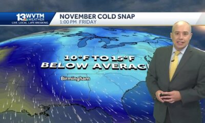
Alabama's weather forecast is getting colder, and a widespread frost and freeze is likely by the …

Judge grants mistrial in Sheila Agee trial due to ‘unhinged juror’

Habitat Restoration Can Appear Messy
French Quarter mass shooting suspects on the run considered 'armed and dangerous'
Long Beach approves lease agreement for casino development
Expert Talk – Senior Medicare Patrol, Danielle Guillory
Fox 14 Your Morning News: Glicked Movie Weekend

Morning weather forecast: 11/22/2024

How Trump’s mass deportation plans could impact Florida

Texas lawmaker makes push to remove death penalty in the state | FOX 7 Austin

3 in custody after 3 killed in Warren County

Yaya Coastal Cuisine brings Mediterranean magic to Miami Waterfront

Salvation Army partners with local businesses to host Hurricane Victims Benefit Concert in Downto…
-
 Local News6 days ago
Celebrate the holidays in Ocean Springs with free, festive activities for the family
-
 News from the South - Georgia News Feed7 days ago
'Hunting for females' | First day of trial in Laken Riley murder reveals evidence not seen yet
-
 News from the South - Alabama News Feed7 days ago
First woman installed as commanding officer of NAS Pensacola
-
 Kaiser Health News4 days ago
A Closely Watched Trial Over Idaho’s Near-Total Abortion Ban Continues Tuesday
-
 Mississippi Today6 days ago
On this day in 1972
-
 News from the South - Alabama News Feed3 days ago
Trial underway for Sheila Agee, the mother accused in deadly Home Depot shooting
-
 News from the South - Georgia News Feed2 days ago
Jose Ibarra found guilty in murder of Laken Riley | FOX 5 News
-
 News from the South - Alabama News Feed3 days ago
Alabama's weather forecast is getting colder, and a widespread frost and freeze is likely by the …