Local News Video
Wesley's Thursday Morning First Alert Forecast
SUMMARY: Temperatures in the region haven’t hit 90°F lately, but Senior Meteorologist Wesley Williams predicts that trend will end today, with highs reaching the lower 90s due to increased sunshine and fewer clouds. Today marks the start of summer at 3:50 p.m., bringing the longest days and hottest weather, peak hurricane activity, and summer activities like barbecues and beach visits. Coastal flood advisories remain for Jackson, Harrison, and Hancock counties. The UV index will be extreme, requiring extra sunscreen. The weekend will stay hot, with highs in the 90s and minimal rain chances, making for a sunny, warm few days ahead.
Welcome to summer! As the season officially changes on the calendar, our trend looks to switch from wetter to hotter heading into the weekend.
For more Local News from WLOX: https://www.wlox.com/
For more YouTube Content: https://www.youtube.com/channel/UCQZgBHlQMqHUV_hf4_9jLLQ


Local News Video
15-minute parking spots added in downtown Gulfport to ease congestion during renovations
SUMMARY: In Gulfport, eight temporary 15-minute parking spots are being added near the Hancock Whitney Bank to reduce congestion during upcoming renovations. The bank building, located across Highway 49, is set to be renovated, though no official start date has been determined. City leaders hope these short-term parking spots will ease traffic by accommodating customers using the bank’s drive-thru, where parking is currently limited, especially at peak times. These spots will remain in place until the renovation work is finished, improving access for customers to enter and exit quickly while construction occurs in downtown Gulfport.
Eight 15-minute parking spots will be temporarily added at the Hancock Whitney Bank in Gulfport. For more Local News from …
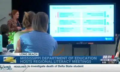
SUMMARY: The Mississippi Department of Education is hosting a series of statewide literacy meetings this month to improve reading skills and family engagement. One meeting took place at Reeves Elementary in Long Beach, aiming to review Mississippi’s Literacy-Based Promotion Act, a 2013 state law promoting comprehensive reading instruction for children. The department and Long Beach School District emphasize the importance of involving families in this process, as a solid literacy foundation benefits children’s lifelong learning and fluency. These meetings provide an opportunity to equip parents with effective tools to support their children’s literacy development and overall success in education and life.
The Mississippi Department of Education is hosting a series of literacy meetings across the state this month.
For more Local News from WLOX: https://www.wlox.com/
For more YouTube Content: https://www.youtube.com/channel/UCQZgBHlQMqHUV_hf4_9jLLQ
Local News Video
Saints Report: Saints lose another close game this time in week two against the San Francisco 49ers
SUMMARY: The New Orleans Saints lost a close game in week two against the San Francisco 49ers, 26-21, at the Caesar Superdome. Despite missing key 49ers players, the Saints struggled early but fought back with touchdowns by Rasheed Shahid and Devon Ble. A critical fourth-down sack of Spencer Rattler sealed their fate. Coach Kell Moore praised the team’s effort but emphasized the need for better situational play and seizing opportunities. The Saints aim to improve as they prepare to face the Seattle Seahawks next Sunday, September 21st. Reporting from the Caesar Superdome, Ever Gier Jr., WXXV News25 Sports.
The Sound of the South: Mississippi’s Songbook

Prosecutors already have dropped nearly a dozen cases from Trump’s DC crime surge, judge says

15-minute parking spots added in downtown Gulfport to ease congestion during renovations

Statewide literacy meetings aim to boost reading skills and family engagement
Rep. Bennie Thompson calling on federal investigation into Delta State student’s death

A Sanctuary in Goodman: The Magic of the Public Library

Suspect in Charlie Kirk killing is charged with murder as prosecutor says DNA found on rifle trigger

Hyde-Smith, Warnock team up to recognize Gold Star Families Remembrance Week

FDA takes aim at Hims and other telehealth services in drug advertising blitz

Saints Report: Saints lose another close game this time in week two against the San Francisco 49ers

Lexington man accused of carjacking, firing gun during police chase faces federal firearm charge

Zaxby's Player of the Week: Dylan Jackson, Vigor WR

Arkansas medical marijuana sales on pace for record year

What we know about Charlie Kirk shooting suspect, how he was caught

US stocks inch to more records as inflation slows and Oracle soars

Russian drone incursion in Poland prompts NATO leaders to take stock of bigger threats

Introducing our WXXV Student Athlete of the Week, St. Patrick’s Parker Talley!

Federal hate crime charge sought in Charlotte stabbing | North Carolina

Weapon recovered as manhunt continues in Kirk assassination investigation | National

NW Arkansas Championship expected to bring money to Rogers
15-minute parking spots added in downtown Gulfport to ease congestion during renovations
Statewide literacy meetings aim to boost reading skills and family engagement
Saints Report: Saints lose another close game this time in week two against the San Francisco 49ers

Harrison County approves budget with no tax increase

‘Little quiet light’: Family remembers Delta State University student found dead on campus

The Mustard Seed

WXXV Game of the Week: Week 3

White House officials hold prayer vigil for Charlie Kirk

Jonesboro band culture responsible for global legacy | FOX 5

Family, friends hold candlelight vigil in honor of Giovanni Pelletier
-

 News from the South - Kentucky News Feed7 days ago
Lexington man accused of carjacking, firing gun during police chase faces federal firearm charge
-
News from the South - Alabama News Feed7 days ago
Zaxby's Player of the Week: Dylan Jackson, Vigor WR
-
News from the South - Arkansas News Feed7 days ago
Arkansas medical marijuana sales on pace for record year
-
News from the South - North Carolina News Feed5 days ago
What we know about Charlie Kirk shooting suspect, how he was caught
-
Local News7 days ago
US stocks inch to more records as inflation slows and Oracle soars
-
Local News6 days ago
Russian drone incursion in Poland prompts NATO leaders to take stock of bigger threats
-
 News from the South - North Carolina News Feed5 days ago
Federal hate crime charge sought in Charlotte stabbing | North Carolina
-
Local News Video6 days ago
Introducing our WXXV Student Athlete of the Week, St. Patrick’s Parker Talley!