News from the South - Louisiana News Feed
1,000 fish died at Calaveras Lake last month. Here’s how often ‘fish kills’ happen and why.
SUMMARY: Recent summers have seen increased temperatures leading to fish kills at Caleris Lake, where about a thousand red drum were reported dead. A Texas Parks and Wildlife Department biologist, Travis Tidwell, explains that these fish kills are often caused by low dissolved oxygen levels in the water. Warm water loses oxygen, especially when there’s little wind and sunlight for photosynthesis. Consequently, fish struggle to breathe, especially overnight when plants do not produce oxygen. Contributing factors may include high fish populations and warm water from nearby power plants. While the dead fish may attract wildlife, they are not advisable for consumption.

Last month, about a thousand dead fish washed up against the banks of Calaveras Lake.


News from the South - Louisiana News Feed
Louisiana lawmakers might revise rejected constitutional amendment on taxes
by Julie O’Donoghue, Louisiana Illuminator
April 1, 2025
Louisiana legislators might put portions of a constitutional amendment overhauling state budget and tax policies back on the ballot, even after voters overwhelmingly rejected the wide-ranging proposal in Saturday’s election.
On Monday, Rep. Julie Emerson, R-Carencro, said she was already working on drafts of new constitutional amendments that would make some of the same budget and tax changes in the failed Amendment 2 from Saturday.
“I think you will definitely see some of this reborn in the session,” Emerson said in an interview, later adding, “I think it is just how we package it, and how many instruments we have with it,”
GET THE MORNING HEADLINES.
The legislators’ annual lawmaking session starts April 14, and any proposed amendments to be considered need to be filed quickly. The deadline to request legislative staff to write up new amendment legislation is noon Tuesday.
“We are all scrambling to get constitutional amendments redrafted again,” Emerson said.
Yet asking the public to reconsider portions of the budget and tax proposal might also be a gamble. Despite a heavy push from Gov. Jeff Landry and some state legislators to approve it, 65% of voters rejected Amendment 2.
In its original form, the proposal would have made dozens of changes to Louisiana’s tax and spending policies, including capping the maximum potential state income tax rate at a lower level and placing new constraints on legislators’ ability to increase state spending.
It would also have made it more difficult for lawmakers to enact new tax breaks while giving them more state money to spend by diverting hundreds of millions of dollars from savings accounts to the state general fund, where the dollars can be used more freely.
Also, public school teachers and school support staff were expected to see pay stipends of $2,000 and $1,000, respectively, they’ve received for the past two years become permanent if the amendment passed. Seniors 65 and over would have seen their standard state income tax deduction double in 2026.
Lawmakers had overwhelmingly voted to put Amendment 2, sponsored by Emerson, on the ballot for voters. Out of 144 lawmakers in the Senate and House, only 11 voted against the measure during a special legislative session devoted to tax policy last November.
But neither Landry nor legislators embarked on campaigns to educate the public about the amendment. Efforts to get out the vote in support of the initiative until the beginning of March, about two weeks before early voting started.
Voters balked at the length and complexity of the proposal, which had run 115 pages as a piece of legislation. Others didn’t feel comfortable voting on one amendment with so many changes that were unrelated to one another.
“It was too much. It was complicated and it didn’t give people options,” said Sen. Franklin Foil, R-Baton Rouge, who had helped Emerson write the Amendment 2 legislation.
Emerson said items she would like to put before the voters again include the larger income tax deduction for seniors 65 and older as well as the rerouting of revenue from state savings accounts to its general fund. Had Amendment 2 passed, the Landry administration wanted to use the money to pay for further cuts to the state income tax rate in the upcoming session.
Lawmakers lowered income taxes for most Louisiana residents just a few months ago, when they adopted a 3% flat income tax in exchange for a higher sales tax. Landry and Republican lawmakers want to eventually eliminate the income tax altogether but need another steady source of state funding to do so.
Foil said he would also like to look at changes that could be made to local property taxes on business inventory.
Amendment 2 would have triggered financial incentives for parish officials to phase out or lessen their inventory taxes. Conservative lawmakers have long wanted to get rid of the tax, which costs the state government money because it partially reimburses businesses for the expense through a state tax credit.
Changes to the inventory tax wouldn’t necessarily require a constitutional amendment and could be made through a regular statute that does not require voter approval, Foil said.
“That’s something we are having conversations about this week, what we might still be able to address,” Foil said.
What remains unclear is what will happen with teacher compensation.
The strategy for making the existing teacher and school support stipends a part of their permanent pay involved draining existing state education trust funds and using the money to pay down retirement system debt.
Even if another constitutional amendment including this strategy was proposed, it wouldn’t go before voters before lawmakers have to address teacher salaries for next year.
That means that teachers and school staff risk seeing their pay cut for the academic year that starts July 1 unless Landry and legislators move money around to keep the extra $2,000 and $1,000 in place for them.
Rep. Jack McFarland, R-Jonesboro, said lawmakers will have to decide whether they want to cut other programs and services to keep teachers and school support staff pay whole. The stipends cost approximately $200 million annually.
“If [lawmakers’] priorities are the teachers’ stipends, then I’m going to have to know it,” said McFarland, who oversees the building of the budget as the House Appropriations Committee chairman.
Emerson and other lawmakers did not say when they would put constitutional amendments on the ballot again. There are no major statewide elections scheduled for the rest of the year, and scheduling another would cost millions of dollars.
Another round of constitutional amendments concerning budget and taxes might face less organized opposition. At least part of the pushback to Amendment 2 was fueled by concern for Amendment 3, a measure to weaken juvenile justice protections.
Amendment 3, which failed on a 66-34 vote split, drew ire from national anti-incarceration groups, resulting in resources for an opposition campaign to Amendment 2 as well. If a similar hot-button measure isn’t on a future ballot, turnout to vote against tax and budget proposals might not be as high.
YOU MAKE OUR WORK POSSIBLE.
Louisiana Illuminator is part of States Newsroom, a nonprofit news network supported by grants and a coalition of donors as a 501c(3) public charity. Louisiana Illuminator maintains editorial independence. Contact Editor Greg LaRose for questions: info@lailluminator.com.
The post Louisiana lawmakers might revise rejected constitutional amendment on taxes appeared first on lailluminator.com
News from the South - Louisiana News Feed
Declining enrollment, money issues cited in St. Paul Catholic School closure announcement
SUMMARY: St. Paul Catholic School in San Antonio is closing after over 70 years, citing declining enrollment, budget shortfalls, and $1 million in deferred maintenance. Enrollment has dropped from over 500 in the 1950s to just 100 today. The school relied on $4 million annually from the parish to operate. Nationwide, Catholic school enrollment has declined over the past decade, though it has recently stabilized. Some hope that proposed school voucher legislation in Texas could boost future Catholic school enrollment, but church leaders say it won’t provide immediate relief. Families like Melanie Romero’s are saddened by the unexpected closure.

In an online statement, the archdiocese said the school has only about 100 students, has had to rely on about $250,000 from the parish each year, and has more than $1 million in deferred maintenance needs.
SUMMARY: The Airship Project, initiated by the United Way of Northeast Louisiana, helps the community protect property by educating them about legal documents like wills and deeds. Part One of the project focused on property title issues after 2020 storms, while Part Two addresses questions about wills and deeds. The goal is to help families understand property protection and ensure their legacies are preserved. Workshops will be held on April 3, April 10, and June 5, offering both in-person and virtual options. Participants can register via the United Way website or call 211. Legal consultations are available through the Northeast Louisiana Bar Foundation.

Louisiana Living: United Way of NELA

Department of Marine Resources offers boating and water safety tips

2nd Annual Taste of Sheffield on April 3 | April 1, 2025 | News 19 at 9 a.m.

Remarkable Women: Ashley Swip honored for work with Three Little Birds 4 Life

'I think everybody's concerned': Mercedes-Benz plant eyeing impact of imported vehicle tariffs

New union 'Education West Virginia' unites WVEA, AFT for stronger collaboration, impact

Behind the Business: Sugar Tribe Sweets and Events

Louisiana lawmakers might revise rejected constitutional amendment on taxes

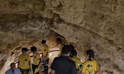
San Antonio students research lunar habitats while inside the Cave Without a Name

Grimes County escapee captured at north Houston motel

State lawmakers agree on school safety bill after Apalachee High shooting

Family mourns death of 10-year-old Xavier Williams

1 Dead, Officer and Bystander Hurt in Shootout | March 25, 2025 | News 19 at 9 p.m.

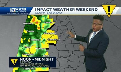
Severe storms will impact Alabama this weekend. Damaging winds, hail, and a tornado threat are al…

University of Alabama student detained by ICE moved to Louisiana

Seafood testers find Shreveport restaurants deceiving customers with foreign shrimp

Why are Oklahomans smelling smoke Wednesday morning?

Tornado watch, severe thunderstorm warnings issued for Oklahoma

Roane County Schools installing security film on windows to protect students

States try to rein in health insurers’ claim denials, with mixed results

Artificial intelligence experiment begins in North Carolina treasurer’s office | North Carolina
2nd Annual Taste of Sheffield on April 3 | April 1, 2025 | News 19 at 9 a.m.
Remarkable Women: Ashley Swip honored for work with Three Little Birds 4 Life
'I think everybody's concerned': Mercedes-Benz plant eyeing impact of imported vehicle tariffs
New union 'Education West Virginia' unites WVEA, AFT for stronger collaboration, impact
Behind the Business: Sugar Tribe Sweets and Events
San Antonio students research lunar habitats while inside the Cave Without a Name
Grimes County escapee captured at north Houston motel
State lawmakers agree on school safety bill after Apalachee High shooting

Declining enrollment, money issues cited in St. Paul Catholic School closure announcement

State and federal pro-life groups endorse Sen. Lindsey Graham for reelection
-

 News from the South - Florida News Feed6 days ago
Family mourns death of 10-year-old Xavier Williams
-
News from the South - Alabama News Feed7 days ago
1 Dead, Officer and Bystander Hurt in Shootout | March 25, 2025 | News 19 at 9 p.m.
-
News from the South - Alabama News Feed5 days ago
Severe storms will impact Alabama this weekend. Damaging winds, hail, and a tornado threat are al…
-
 News from the South - Alabama News Feed4 days ago
University of Alabama student detained by ICE moved to Louisiana
-
News from the South - Louisiana News Feed6 days ago
Seafood testers find Shreveport restaurants deceiving customers with foreign shrimp
-
News from the South - Oklahoma News Feed6 days ago
Why are Oklahomans smelling smoke Wednesday morning?
-
News from the South - Oklahoma News Feed3 days ago
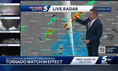
Tornado watch, severe thunderstorm warnings issued for Oklahoma
-
News from the South - West Virginia News Feed6 days ago
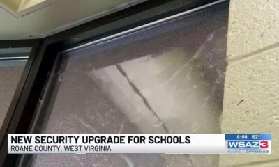
Roane County Schools installing security film on windows to protect students